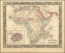
![Africa / Lybia / Morland / mit allen kunigsreichen so zu unsern zeiten darin gefunden werden [Afrika/Libyen/Morenland, with all the kingdoms found therein in our time] By Sebastian Munster](https://storage.googleapis.com/raremaps/img/small/95771.jpg)


|
||

|

|
|

|
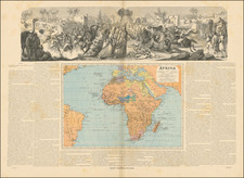
The First Modern Map of Africa
Fine example of Münster's first map of Africa. It is the first map of the entire continent to depart from the Ptolemaic outline to adopt a modern portrayal. The map featured in his famous Cosmographia universalis (1544-1628), as well as in Münster’s other notable work, his version of Ptolemy’s Geographia (1540-52).
Münster was the first mapmaker to show each of the four known continents on their own plates on a modern model and his map of Africa is widely accepted as the first map of the entire, navigable African continent. The map is based in part on Ptolemy, but also includes modern Portuguese and Arabic information.
The coastal outline of Africa had only recently been understood by Europeans. Bartolomeo Dias had rounded the Cape of Good Hope in 1488, while Vasco de Gama reached India by sea a decade later. The cartouche in the lower left details sailing directions from Lusitania (Iberian Peninsula) to Calcutta. The Portuguese caravel in the Gulf of Guinea represents trade and navigation and the cartouche in the lower left describes the journey.
The map is richly illustrated with vignettes, including tropical birds in southern Africa. In what is today Nigeria and Cameroon, there is a Cyclops or one-eyed man, a reference to the fabled tribe of the Monoculi. In Southern Africa, an elephant with impressive tusks faces the Indian Ocean.
The map depicts numerous kingdoms, marked by a scepter within a crown. Towns and cities dot the continent, mostly along the northern coast and Nile River. They include Meroë, where the Nubian kings are said to be buried, and Prester John’s fabled settlement.
The Nile is sourced from twin lakes and a mountain range. Although the mountains are not labeled here, they are identifiable as the Mountains of the Moon. Ptolemy describes such a lakes-and-mountains layout in his works, although the precise identification of the Mountains of the Moon may have been a fourth century addition to his text. Sixteenth century mapmakers, including Waldseemüller and Münster, chose to follow the Ptolemaic model. This was typical of cartographers at the time, who had abandoned Ptolemy’s coastlines in favor of the more recent Portuguese outlines yet who also clung to Ptolemaic place names for the interior of Africa well into the nineteenth century.
Münster also speculates as to the sources of the Niger and Nile Rivers, as well as places a curious forest in the middle of the Sahara Desert, near the label for Libya. A desert forest is not the most interesting geographic feature on the map, however. There is a curious loop of the Senegal River, which is actually the true route of the Niger River. However, the loop disappears on subsequent maps and is only confirmed, in an altered state, thanks to the expedition of the Lander brothers in 1830.
European mapping of Africa to ca. 1550
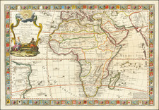
Medieval mapping of the African continent was tied to the Christian worldview. Traditionally, the known world of Antiquity, which included the north of Africa, Asia, and Europe, was arranged symbolically in what is known as a T-O map. Such world images were common in Medieval manuscripts and they show the three landmasses in a T shape with an O, the ocean, surrounding them. The T-O maps are east-oriented—Paradise and Eden were supposedly located to the east—and some have Jerusalem at their center. Europe is in the bottom left corner and Africa the bottom right.
Over the course of the Medieval period, mappaemundi on the T-O model were increasingly stuffed with new place names and features, particularly those mentioned in the popular travel narratives of Marco Polo and Sir John Mandeville.
From roughly 1200, portolan charts showed increasing portions of the African coast. Meant for maritime navigation, these charts contained little to no information about the interior of the continent. They did, however, reflect the advancement of European, particularly Portuguese ships south along on the west coast of Africa. The culmination of these voyages was in 1498, when Vasco da Gama rounded the Cape of Good Hope and reached the Indian subcontinent.
Da Gama’s forging of an all-water route to India was particularly illuminating when compared with the prevailing geographic theories of the day, which were dominated by work of the second-century AD Alexandrian scholar, Claudius Ptolemy. Ptolemy postulated in his famous work, Geographia, that the Indian Ocean was enclosed by land which stretched from the south of Africa to southeast Asia. Early modern scholars were already questioning Ptolemy, however, even before da Gama reached India. For example, the Fra Mauro map has a peninsular southern Africa with a waterway flowing around it.
Early printed editions of Ptolemy—the first with maps was printed in 1477 in Bologna—would increasingly include tabula nova, or new maps, which supplemented Ptolemy’s ideas with more modern observations. The first edition to include the Portuguese discoveries in Africa was the Rome edition of 1508. The first surviving printed map to include the discoveries was the earlier Contarini-Roselli world map of 1506, the only surviving example of which is at the British Library.
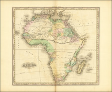
Martin Waldseemüller’s 1507 world map, the sole example of which is now at the Library of Congress, also shows the revised version of the continent. Additionally, Waldseemüller included the new discoveries in his Africa maps for an edition of Ptolemy published in 1513. The first modern map of the entire African continent was in Sebastian Münster’s edition of the Geographia published in 1540 (and his Cosmographia of 1544). After Münster, Ortelius’ 1570 map was the first widely-distributed map of the continent and it would popularize the ideas of Giacomo Gastaldi, his main source. It also inspired other maps, like the second map of Africa included in later editions of the Cosmographia.
Sebastian Münster (1488-1552) was a cosmographer and professor of Hebrew who taught at Tübingen, Heidelberg, and Basel. He settled in the latter in 1529 and died there, of plague, in 1552. Münster made himself the center of a large network of scholars from whom he obtained geographic descriptions, maps, and directions.
As a young man, Münster joined the Franciscan order, in which he became a priest. He then studied geography at Tübingen, graduating in 1518. He moved to Basel, where he published a Hebrew grammar, one of the first books in Hebrew published in Germany. In 1521 Münster moved again, to Heidelberg, where he continued to publish Hebrew texts and the first German-produced books in Aramaic. After converting to Protestantism in 1529, he took over the chair of Hebrew at Basel, where he published his main Hebrew work, a two-volume Old Testament with a Latin translation.
Münster published his first known map, a map of Germany, in 1525. Three years later, he released a treatise on sundials. In 1540, he published Geographia universalis vetus et nova, an updated edition of Ptolemy’s Geographia. In addition to the Ptolemaic maps, Münster added 21 modern maps. One of Münster’s innovations was to include one map for each continent, a concept that would influence Ortelius and other early atlas makers. The Geographia was reprinted in 1542, 1545, and 1552.
He is best known for his Cosmographia universalis, first published in 1544 and released in at least 35 editions by 1628. It was the first German-language description of the world and contained 471 woodcuts and 26 maps over six volumes. Many of the maps were taken from the Geographia and modified over time. The Cosmographia was widely used in the sixteenth and seventeenth centuries. The text, woodcuts, and maps all influenced geographical thought for generations.