


|
||

|

|
|

|
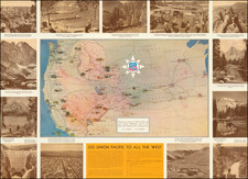
Marvelous map of the US, ten years prior to Texas' Independence. The treatment of the oversized 54-40 or fight Oregon Territory, Missouri Territory and the region west of the Mississippi is especially interesting. Most notable are the Spanish names appearing along the western porion of the Southern Mississippi River for the regions which would become Missouri and Arkansas and Missouri, including Lawrence, Cape Girardeau, Howard and St. Louis. These names are districts derived originally under French and later the Spanish control of the Louisiana Territory. The appearance of Howard District is especially unusual, perhaps the only example on a printed map. The map is rich with Indian names, far more than typical. This is especially true in the Northwest and may be as a result of the recent dissemination of the account of Hunt & Stuart which only recently been published in French in the Nouvelle Annales des Voyages, the only contemporary account of their trip to and from Astoria, which resulted in the discovery of the South Pass and first use of what would become the Oregon Trail. A striking map from a fascinating time period in American history.