|
||

|

|
|

|
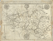
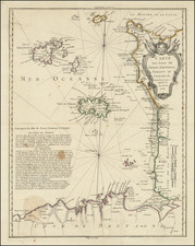
Important Early Map of Bretagne
Rare map of Brittany that originally appeared in Maurice Bouguereau's Le Theatre Francoys, considered the first national atlas of France.
The map initially introduces the region it shows as Armorica, taking the ancient name for Brittany. It is highly detailed, with many cities and towns named. Relief and forests are shown pictorially.
The map is embellished with a coat of arms and three wind roses. The sea is attractively stippled, and the map itself is decoratively presented.
With a few exceptions, Bouguereau's maps are pilfered from previous sources. This map follows the map of the same title which appeared in Betrand d'Argente's 1588 Histoire de Bretaigne.
The swirls which adorn the coastlines are not merely an engravers fancy: they track from various bays to three tidal charts, delimiting the time of high tide on a particular day of the lunar cycle.
Le Theatre Francoys
This very rare volume is understood to be the first national atlas of France. Published in Tours during the French king's exile from Paris, this work reunites maps of northern and central France.
Many of the maps in the volume are copied from earlier Ortelius and Mercator sources, although some, particularly in the region around Tours, are original maps. These maps would be reused by later authors, including Hondius, Blaeu, and Jansson. All the maps in the text are engraved by Tavernier.
The volume suffered from a lack of spatial completeness, with much of the south of France lacking any coverage. While Bouguereau put a plea for more maps in his introduction, subsequent, more complete editions of this work would not be published until well into the 17th century. The first complete edition would appear in 1642 under the name Theatre Geographique due Royaume de France.
Rarity
Bouguereau's maps are extremely rare.