This item has been sold, but you can enter your email address to be notified if another example becomes available.


|
||

|

|
|

|
Stock# 7829
Description
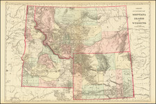
Highly detailed map of the upper Plains and midwest and portion of the Rockies. The map illustrates the extraordinary attention to detail exhbited by Stieler's maps, showing towns, dozens of roads, mountains w/elevations, lakes, rivers, Forts, Indian Tribes & Reservations, mines, springs, forests, valleys, etc. It may safely be said the Steiler's maps were the most detailed atlas maps of the period, surpassing even the best American atlases on detail w/in the US.

![[Run of 6 Volumes] Report Upon Geographical Surveys West of the 100th Meridian](https://storage.googleapis.com/raremaps/img/small/74064.jpg)