


|
||

|

|
|

|
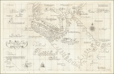
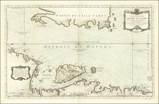
Striking Map of the Strait of Magellan
Detailed map of the Strait of Magellan, based on the work of renowned Spanish geographer, Juan de la Cruz Cano y Olmedilla.
The map shows the winding strait in considerable detail, as well as highlights the inlets and passages that crisscross the archipelago of Tierra del Fuego to the south. The eastern entrance to the Strait is filled with sounding depths to aid a navigator. On both banks, north and south, are notes about the local peoples and the landscape. In several places, giants are mentioned, a persistent European obsession that sprung when large footprints were spotted by the first crew of Europeans to enter the Strait, under the command of Ferdinand Magellan.
The inset shows far southern South America and the Falkland Islands nearby. These islands were newly disputed when the map was published. Although the Spanish laid claim to them by extension of their nearby continental holdings, the French set up a settlement in 1763. One year later, in 1764, Commodore John Byron visited and also made a claim. The British then sent the Jason to further their imperial pursuits, only to find the French and to meet with Spanish diplomatic objections. The British had to drop their claim (for the moment) and the French formally handed over the settlement to the Spanish. This map continues the search for a British historical title to the archipelago, as it mentions Hawkins Maiden Land, a sighting made by the privateer John Hawkins in the late sixteenth century.
Some of the place names in the Strait are recent; for example, a Bay Bougainville alludes to Louis Antoine de Bougainville, who had traversed the Strait during the first French circumnavigation (1766-1769). Others are much older. Port Famine was named as such by Thomas Cavendish, who stopped by during his own circumnavigation in 1587. He picked up a single survivor of an ill-fated Spanish settlement, leaving at least sixteen others to their deaths.
This Spanish colony was founded at the encouragement of Pedro Sarmiento de Gamboa, whose name is also mentioned several times on the map. Sarmiento was part of the crew of Álvaro de Mendaña’s expedition that visited the Solomon Islands (1567-9). In response to Francis Drake’s use of the Strait to enter the Pacific during his circumnavigation (1577-1580), Gamboa was ordered to the Strait in 1580. He observed the area closely and then returned to Spain where he asked to set up a colony to protect the strategic passageway. This was the origin of the unfortunate souls later encountered by Cavendish.
Another Spanish reactionary expedition is also mentioned here, when place names are so called “according to the Nodales.” These are the Nodales brothers. They were ordered to reconnoiter the region after a Dutch voyage, led by Le Maire and Schouten, found a new passage into the Pacific via Cape Horn. With the brothers was their pilot, Diego Ramírez, whose name is on islands to the southwest of the Strait on this map, as well as on an island near Cape Horn on the inset.
This English version of the map appears most frequently in Thomas Jeffery's American Atlas. It was based on a similar map (without the inset) by Cano y Olmedilla that featured in Casimiro de Ortega’s Spanish edition of the Byron circumnavigation (1764-6), a work that included a special section on the geography of the Strait of Magellan and Tierra del Fuego. The region was of increasing geopolitical interest in the 1760s, hence the interest in this map for both Spanish and English audiences.
Robert Sayer (ca. 1724-1794) was a prominent London map publisher. Robert’s father was a lawyer, but his older brother married Mary Overton, the widow of prominent mapmaker Philip Overton and the proprietor of his shop after his death. Mary continued the business for roughly a year after her marriage and then, in early 1748, it passed to Robert. Robert became a freeman of the Stationers’ Company later that year; his first advertisement as an independent publisher was released in December.
Sayer benefited from Overton’s considerable stock, which included the plates of John Senex. In the 1750s, Sayer specialized in design books and topographical prints, as well as comic mezzotints. In 1753, he, along with John Roque, published a new edition of Thomas Read’s Small British Atlas, the first of several county atlases that Sayer would publish.
Sayer’s business continued to grow. In 1760 he moved further down Fleet Street to larger premises at 53 Fleet Street. In 1766, he acquired Thomas Jefferys’ stock when the latter went bankrupt. In 1774, he entered into a partnership with John Bennett, his former apprentice. The pair specialized in American atlases, based on the work of Jefferys. They also began publishing navigational charts in the 1780s and quickly became the largest supplier of British charts in the trade.
Bennett’s mental health declined, and the partnership ended in 1784. As Sayer aged, he relied on his employees Robert Laurie and James Whittle, who eventually succeeded him. He spent more and more time at his house in Richmond. In 1794, he died in Bath.
John Bennett (fl. 1760-d. 1787) was a London printer best known for his role in the successful partnership of Sayer & Bennett. In 1760, Bennett became a servant of Robert Sayer (ca. 1724-1794), the prominent print and map seller, and was apprenticed to him in 1765. In 1774, Bennett became a free journeyman and entered into a partnership with Sayer. They issued joint advertisements and publications. In 1777, Bennett owned 1/3 share in the business. The partnership was likely to continue fruitfully, but in 1781 Bennett began to show signs of mental illness. In 1783, he was admitted to an asylum for nine months and, in 1784, Sayer filed papers to dissolve their business partnership. Bennett died in 1787.
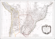
![[ Patagonia / Chile / Argentina ] A New Map of the Southern Parts of America taken from Manuscript Maps made in the Country and a Survey of the Eastern Coast made by Order of the King of Spain.](https://storage.googleapis.com/raremaps/img/small/100772.jpg)