|
||

|

|
|

|
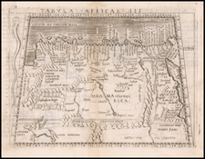
The First Map of The Spanish Equatorial Guinea Province of Rio Muni
A phenomenal map of Spanish Equatorial Guinea, published shortly after the Treaty of established the Rio Muni province of Spanish Equatorial Guinea in 1900.
Then also known as Continental Spanish Guinea or Rio Muni, the present map provides a minutely detailed treatment of the province, the first attempt to provide a meaningful and useful mapping of the region
The map provides the first meaningful mapping of the region, along set of historical notes and minute treatment of tribal names, indigenous populations, Catholic Mission, factories, roads, paths and topographical details of the region, along with location and districts of the boundary commission.
The map was prepared by Enrique d'Almonte y Muriel, an important Spanish Colonial mapmaker and geographer, who had been sent to Rio Muni following the Franco-Spanish Treaty of Paris in 1900, specifically to work as part of the boundary commission to establish the new border between the French Congo and Spanish Equatorial Guinea, and also to survey the region for the Spanish Royal Geographical Society, as a means of developing trade and expanding plantations.
This work was followed by a broad expansion of investment and farming in the region over the next several decades, along with several articles written by D'Almonte urging a broader colonial exploitation of the natural resources of the region.
Spanish Equatorial Guinea
Río Muni was part of the region ceded by Portugal to Spain in 1778 in the Treaty of El Pardo, which also included Fernando Po, which became a more productive region for the Spanish. The Spanish had hoped to collect slaves to work in their other overseas possessions, but their settlers died of yellow fever and the area was deserted. Cocoa and timber became major industries upon recolonization. Río Muni, along with Bioko, became a province of Spanish Guinea in 1959.
The treaty of Paris in 1900 left Spain with the continental enclave of Rio Muni, less than ten percent of the area stretching east to the Ubangi river which the Spaniards had initially claimed. The enclave was far smaller than what the Spaniards had considered themselves rightfully entitled to under their claims and the Treaty of El Pardo, which was considered a great humiliation of the Franco-Spanish negotiations.
The early twentieth century saw a new generation of Spanish immigrants. Land regulations issued in 1904–1905 favored Spaniards, and most of the later big planters arrived from Spain thereafter. An agreement made with Liberia in 1914 to import cheap labor greatly favored wealthy men with ready access to the state, and the shift in labor supplies from Liberia to Río Muni increased this advantage. Allowing a more successful exploitation of the region, although chronic labor shortages for the plantations was a perennial issue.
Enrique d'Almonte y Murielwas a Spanish cartographer and geographer, active in the Spanish colonial regions such as the Philippines and Spanish Africa, including both Guinea and in the Spanish Sahara.
D'Almonte first settled in the Philippines in 1880 as an part of the of the Inspección General de Minas de Filipinas. This work allowed him to reconoiter a large part of the islands and carry out different cartographic surveys and descriptions of the Philippines, beforereturning to Spain in 1897. While in the Philippines, D'Almonte made maps of Luzon and adjacent islands, the province of Manila and districts of Leite, Samar, Negros and Bohol.
After being being nominated to the Madrid Geographical Society, he carried out various topographic and cartographic works in the Spanish Equatorial Guinea province of Muni, as a member of the commissions that established the borders between the Spanish colony and the neighboring French Congo and German Cameroon.
D'Almonte made 2 trips to Equatorial Guinea, the first in 1901, following the signing of tghe Franco-Spanish Treaty of 1900, which established that the called for setting the borders between the Spanish and French Colonies. D'Almonte was part of the first set of boundary commissioners which met in Bata in July 1901. In addition to the border surveys, the Spanish royal commission also commissioned d'Almonte to to conduct a thorough study of the Rio Muni as a cartographer and geology expert at the request of the Madrid Geographical Society. D'Almonte remained in Muni until the end of October, 1901 and as a result of his observations he published two works: a text in 1902 in which he describes Fernando Pó and Spanish continental Guinea and a map of Rio Muni at a scale of 1: 200,000 in 1903.
He returned to Africa for the second time in 1906, as a result of his appointment by the Government as a special delegate in charge of setting the boundaries between the Spanish and German possessions. As a result, he published the book Someras notas, where he published his observations on the geography, geology and Spanish colonization of Guinea, alont with a map of the region, on a scale of 1: 200,000 and a map of Fernando Pó, on a scale of 1: 50,000, and his Sinopsis botánica de la Guinea. D'Almonte presented is work at a conference of the Royal Geographical Society in 1907, with his papers published in 1908.
In 1912, he published a final summary of his experience in the colony, stressing the urgency and opportunity of exploiting the resources of the colony for Spain. ]In fact, in the words of D'Almonte himself, "there is no other colony endowed with more natural wealth and with more latent positive elements of progress." He published a further paper on the importance of pursing the viability of the Mun
D'Almonte carried on further work in the Philippines and Spanish Saharan Africa, earning a number of important acolades, before his untimely death as a result of a mine near the Cape of Good Hope in 1917, while undertaking a mission to open direct navigation service between Japan and Spain.
![(Horn of Africa) Abessinien Somaliländern [cover title:] Neue Karte von Abessinien und Somaliländern](https://storage.googleapis.com/raremaps/img/small/97482.jpg)