|
||

|

|
|

|
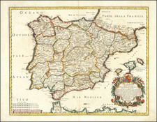
Highly detailed map of Spain and Portugal, showing coats of arms of various principalities and substantial detail. This finely engraved map first appeared in Chatelain's monumental seven-volume Atlas Historique, one of the most famous and prolific works of the early 18th century.
An index in the bottom right lists the principal towns of the region, and a detailed note explains that while history is nebulous, so is geography, and place names vary wildly. The note says that one has just to compare Ptolemy's geography to a modern author's work to understand this.
The map is highly detailed, with notes throughout. A key shows where various institutions, such as inquisition sites and universities, can be found. In all, an interesting map with much detail.
Henri Abraham Chatelain (1684-1743) was a Huguenot pastor of Parisian origins. Chatelain proved a successful businessman, creating lucrative networks in London, The Hague, and then Amsterdam. He is most well known for the Atlas Historique, published in seven volumes between 1705 and 1720. This encyclopedic work was devoted to the history and genealogy of the continents, discussing such topics as geography, cosmography, topography, heraldry, and ethnography. Published thanks to a partnership between Henri, his father, Zacharie, and his younger brother, also Zacharie, the text was contributed to by Nicolas Gueudeville, a French geographer. The maps were by Henri, largely after the work of Guillaume Delisle, and they offered the general reader a window into the emerging world of the eighteenth century.
![[ Tracking The Armies of Bonaparte and the English During The Peninsular Campaign ] New Map of Spain and Portugal By E. Mentelle, Member of Institute of Science at Paris, and P. G. Chanlaire, One of the Authors of the National Atlas](https://storage.googleapis.com/raremaps/img/small/99148.jpg)
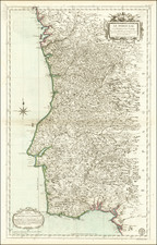
![Parte Septentrional do Reyno de Portugal... 1654 [with] Partie Meridional do Reyno de Portugal.... 1654](https://storage.googleapis.com/raremaps/img/small/50470.jpg)