|
||

|

|
|

|
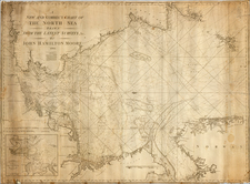
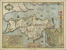
With Hand Annotated Reference To the Goodwin Sands
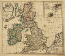
Striking map of England, with costumed figures, a compass rose and a detailed table of the Shires of England, published by John Speed and engraved by Abraham Goos.
Originally drawn from the map of Christopher Saxton, this is the second of Speed's maps of "The Kingdome of England," the first having been engraved by Jodocus Hondius. The first state of the map was engraved by Jodocus Hondius in 1610. In this state, the lower left-hand corner has the credit to Abraham Goos and the year 1632.
The map appeared in John Speed's The Theatre of the Empire of Great Britaine.
Goodwin Sands
Goodwin Sands is a 10-mile-long sandbank at the southern end of the North Sea lying 6 miles east of the Deal coast in Kent, England. The area consists of a layer of approximately 80 feet of fine sand resting on an Upper Chalk platform belonging to the same geological feature that incorporates the White Cliffs of Dover.
More than 2,000 ships are believed to have been wrecked upon the Goodwin Sands because they lie close to the major shipping lanes through the Straits of Dover. The few miles between the sands and the coast is also a safe anchorage used as a refuge from foul weather known as The Downs.
Notable shipwrecks include HMS Stirling Castle in 1703, VOC ship Rooswijk in 1740, the SS Montrose in 1914, and the South Goodwin Lightship, which broke free from its anchor moorings during a storm in 1954. Several naval battles have been fought nearby, including the Battles of the Goodwin Sands in 1602 and in 1652, and the Battle of Dover Strait in 1917.
John Speed (1551 or '52 - 28 July 1629) was the best known English mapmaker of the Stuart period. Speed came to mapmaking late in life, producing his first maps in the 1590s and entering the trade in earnest when he was almost 60 years old.
John Speed's fame, which continues to this day, lies with two atlases, The Theatre of the Empire of Great Britaine (first published 1612), and the Prospect of the Most Famous Parts of the World (1627). While The Theatre ... started as solely a county atlas, it grew into an impressive world atlas with the inclusion of the Prospect in 1627. The plates for the atlas passed through many hands in the 17th century, and the book finally reached its apotheosis in 1676 when it was published by Thomas Bassett and Richard Chiswell, with a number of important maps added for the first time.