|
||

|

|
|

|
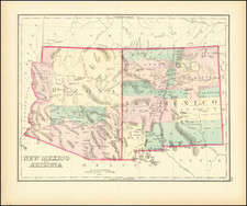
Important early map of parts of New Mexico and Arizona, prepared during the survey explorations and military campaigns in New Mexico and West Texas in 1849.
Prepared by Topographical Engineer James H. Simpson and the artist Edward Kern, the map reports the route and observations from an expedition against the Navajos led by Colonel John M. Washington, the military governor of New Mexico, in 1849. The campaign was an important one, as Wheat observes, "following up that of Colonel Doniphan in 1846 before he went on to Mexico, and though the Indians remained restless it served its primary purpose of preserving the New Mexican settlements from Navajo raids." The expedition traveled northwest from Santa Fe by way of the Jemez Pueblo and over the Jemez Mountains to Chaco Canyon and finally to Canyon de Chelly, "the very citadel of the Navajos," as Goetzmann notes, where a treaty with the Navajos was signed.
Simpson's map presents the route of the expedition as a red line. He designates campsites by numbers and sometimes by star symbols, which "denote points determined by astronomical observations." The return route went south from Chelly canyon to Zuñi Pueblo, past Inscription Rock, on to Laguna Pueblo and Albuquerque, and finally back to Santa Fe. Wheat calls the map "an arresting production, bringing out many new details of the region directly west of New Mexico." This seldom-seen map is a noteworthy document of Simpson's significant contribution to the archaeology of the Southwest.
Simpson and Kern mapped the route, and Kern's brother Richard, also an artist, created illustrations of Pueblo Indian settlements, Indian leaders, and archaeological ruins at Chaco and Chelly canyons. The most important contribution of the expedition was its discovery of these spectacular ruins, which Simpson recorded with his usual precision. Simpson was "the first American to make an accurate eyewitness survey of the region west of the Rio Grande past the Puerco. . .," writes Goetzmann. "As such, his report was the forerunner of the later works by Morgan and Bandelier."
The map was published in "Report of the Secretary of War..." by Joseph Eggleston Johnston, J.H. Simpson and others (Wagner-Camp 184), with "Senate Ex. doc. 1st Sess. 31st Cong. No. 64" in upper right margin, "P.S. Duval's Steam Lith. Press, Philada." at the bottom of the title block.
Wheat used the map as the frontispiece in Volume III of Transmississippi West.
James Hervey Simpson (1813–1883) was a distinguished officer in the U.S. Army and an influential member of the United States Corps of Topographical Engineers.
Early Life and Military Beginnings Born on March 9, 1813, in New Brunswick, New Jersey, Simpson was the son of John Simpson and Mary Brunson. His military career began with his graduation from the United States Military Academy in 1832, leading to his initial assignment with the 3rd U.S. Artillery. Simpson's early service included participation in the Second Seminole War, during which he was promoted to first lieutenant in 1837.
Topographical Engineers In 1838, Simpson transitioned to the U.S. Army's Topographical Engineers, a distinct department focusing on mapping and construction projects. He first assisted Cpt. W. G. Williams with harbor construction on Lake Erie and later worked on road construction in Florida and lake surveys in Wisconsin and Ohio. By 1845, he was overseeing the harbor of Erie, demonstrating his growing expertise in topographical engineering.
New Mexico Expedition, 1849 Simpson’s notable westward journey commenced in 1849 under Colonel John James Abert. He surveyed a road from Fort Smith, Arkansas to Santa Fe, New Mexico, and participated in a punitive raid against the Navajo. Simpson's work included collaboration with artists Edward and Richard Kern, resulting in valuable sketches and artwork from the expedition. His successful endeavors in New Mexico led to his appointment as the Chief Topographical Engineer for the Ninth Military Department in Santa Fe.
Other Duties and Utah Expedition Simpson continued his distinguished service by surveying and improving roads in Minnesota in 1851 and was promoted to captain in 1853. His transfer to Florida saw him overseeing survey work for the United States Coast Survey. The Utah Expedition of 1858-59 was a significant chapter in his career. Tasked with mapping routes during the Utah War, Simpson surveyed a wagon road between Camp Floyd and Fort Bridger and conducted reconnaissance into the Great Salt Lake Desert. His expedition in 1859, which included photographer Samuel C. Mills, was crucial for mail, freight, and passenger transportation and laid the groundwork for the Transcontinental Telegraph.
Civil War Service During the Civil War, Simpson served as colonel of the 4th New Jersey Volunteer Infantry, was captured at the Battle of Gaines's Mill, but was later paroled. He resigned his volunteer commission to return as a major in the Corps of Topographical Engineers, where he contributed to the defenses of Cincinnati, Ohio. His wartime service earned him the brevet rank of brigadier general.
Later Career and Legacy In his later years, Simpson served as chief engineer of the Interior Department and oversaw the construction of the Transcontinental Railroad. He retired to St. Paul, Minnesota, in 1880 and passed away there on March 2, 1883. His name endures in geographical features such as the Simpson Park Mountains in Nevada, the Simpson Mountains in Utah, and the Simpson Springs Pony Express Station, all of which commemorate his significant contributions to American topographical engineering and exploration.
![[ New Mexico - West Texas ] Estacaco Plain (406) World Aeronautical Chart](https://storage.googleapis.com/raremaps/img/small/96896.jpg)