The item illustrated and described below is sold, but we
have another example in stock. To view the example which
is currently being offered for sale, click the
"View Details" button below.


|
||

|

|
|

|
Stock# 78187
Description
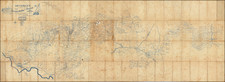
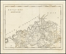
One of the earliest printed maps of the State of Kentucky.
The map provides a fine and extensive treatment of Kentucky's early roads. Numerous towns and courthouses are also shown, along with the Rapids below Louisville on the Ohio River.
Includes an early appearance of Fort Washington or Cincinnati on the Ohio River.
States of the Map
The map is known in four states:
- State 1 (1796): No roads shown.
- State 2 (1801): In the border, a line has been added through the numerals '85' and '10' degrees longitude. Buck Cr.is named directly below the label Ohio R. and Shelbyville, Springfield, Somerset, Franklin, Crab Cr and Preston are added.
- State 3 (1805): To the north of Kentucky, North Wn. Territory, and Ohio are shown above and Tennessee below. Many more place names and roads added.
- State 4 (1813): North Wn. Territory has been removed and replace with Illinois and Indiana.
Condition Description
Overleaf toning. Minor uneven toning.