|
||

|

|
|

|
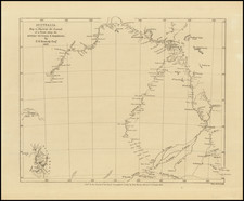
Terrific regional map of Australia, extending from Skirmish Point and Mt. Brisbaine on the eastern coastline to Pt. Fowler and Fowler's Bay in the west, with an inset of Norfolk Island. A huge Lake Torrens is shown north of Spencer's Bay, indicating that it is mostly dry on the surface. Nice detail all around Spencer's Gulf. The coastline of Australia Felix and around Melbourne and interior mountain and rivers system is well shown. The most detail is best in the Sydney and Blue Mountains regions. A key names 20 counties or districts. The Bogan, Darling, and Murray river systems are shown in the interior, often with conjectural courses in the less known regions. A nice early map of the settled part of Australia. Adam & Charles Black were among the leading publishers of atlases and travel books in the 19th Century England.