|
||

|

|
|

|
Stock# 78132
Description
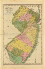
One of the Earliest American-Printed Maps of New Jersey
Detailed map of New Jersey, from Morse's Universal Geography. This fantastic depiction of the state shows rivers, a number of towns, and the start of the Appalachians. Part of New York, Long Island, and Staten Island are visible.
The map was engraved by Samuel Hill, a famous early American engraver who collaborated with Morse on a number of cartographic projects. This copperplate engraving first appeared in Morses' The American Universal Geography, one of the earliest American-published atlases.
Reference
Wheat & Brun 417.
![[Theater of American Revolution / 1776] A Map of the Country round Philadelphia including Part of New Jersey New York Staten Island & Long Island](https://storage.googleapis.com/raremaps/img/small/86066.jpg)