|
||

|

|
|

|
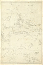
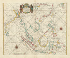
The Western Pacific at the Close of the Eighteenth Century
Fine German map of Southeast Asia, the Philippines, Australia, Polynesia, and the surrounding waters.
While the area is densely populated with islands and toponyms, there are still many unfinished and uncharted coastlines, including Papua New Guinea, New Britain, New Georgia, New Caledonia, and Australia itself.
A partial shore is tucked south of New Britain. This is the Louisiade Archipelago, which was sighted by Louis-Antoine de Bougainville in 1768. It was possibly sighted earlier, however, by Chinese and Malay sailors.
The map includes the findings of all three of Cook’s voyages, including a complete outline of New Zealand, the east coast of Australia, and the Sandwich Islands, now known as Hawai’i.
The outline of Australia is a mixture of Dutch encounters, the toponyms of Cook’s first voyage, and the findings of the nascent penal colony near Port Jackson and Botany Bay. The continent is called New Holland, in reference to the Dutch, and Ulimaroa. The latter name was bestowed on the landmass by Swedish geographer Daniel Djurberg in 1776. It is a misunderstood use of a Māori word mentioned in Hawkesworth’s account of Cook’s first voyage. It actually refers to Grand Terre, the largest island of New Caledonia.
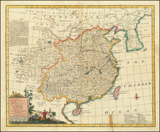
The Dutch Encounter with Australia
Whereas the Portuguese were the first Europeans to tap the lucrative resources of the East Indies, other European powers quickly joined the race. The VOC, founded in 1602, was based in Amsterdam with a local headquarters in Batavia (Jakarta).
Dutch ships roved the waters of the Indian Ocean. A few crossed the sea at southern latitudes, taking advantage of the winds of the roaring forties, which put them on a collision course with the continent of Australia, then still unknown to Europeans. These ships were following the Brouwer Route to Jakarta, so-called because it was explored in 1611 by Hendrick Brouwer. Less than five years later, it was named the prescribed route from the Cape of Good Hope to Java and following the route was compulsory for all VOC ships, unless they were destined directly for China and Ceylon, rather than Batavia.
Ships were supposed to turn north when they sighted Amsterdam Island or St. Paul Island. However, the methods for calculating longitude in the seventeenth century were imprecise and some ships continued east, eventually running afoul of the Australian coast.
The first of these to contact West Australia was the Eendracht in 1616, which was blown off course en route to the East Indies. It was commanded by Dirk Hartog and Hartog’s landing was the first recorded European landing on the western coast of Australia. It is marked here with Dirk Hartogs I. and Eintrachts Land enteckt 1615. The crew commemorated their discovery by erecting a post with a pewter dish inscribed with their ship’s information—the earliest physical record that historians have of any European landing in Australia.
Other voyages also sighted or landed in Western Australia in the 1620s. This map references that of Gerrit Fredericsz De Wit in 1628 (here erroneously 1616), of the Leeuwin in 1622 (Löwensland), and of Pieter Nuyts, who commanded the Gulden Zeepaert along the southern coast in 1627 (here erroneously 1727).
By the 1640s, the officials of the VOC were eager to know the extent of the south lands and if they included any useful resources or willing trading partners. They appointed Abel Tasman to pursue these questions. Tasman's 1642-43 voyage was the first to circumnavigate the whole of the Australasia region, thus proving it was a separate entity unconnected from a mythical, and massive, southern continent. He surveyed the south coast of Tasmania, which he called Van Diemens Land after the VOC governor of Batavia, and the western coast of New Zealand, as well as the Tonga and Fiji Archipelagos. While important for geography, his voyage was nevertheless a disappointment to the VOC, as it netted no new commercial opportunities.
His second voyage proved even less successful. He was supposed to find a passage south of New Guinea to the east coast of Australia, but he missed the strait and instead thought it a bay. He did, however, more fully chart Australia’s northern coastline, which had only been sporadically encountered to that point. Previously, information for the north coast, especially for portions of the coasts in what it today Queensland, Australia, come from the voyage of the Dutch vessel Duyfken in 1605-06. Under the command of Willem Janszoon, the Duyfken explored the eastern shore of the Gulf of Carpentaria, just below the Cape York Peninsula, a venture which was famously the first recorded European contact with Australia. Also here is the sighting of the northern coast by the Arnhem in 1623 (here erroneously 1618).
Cook's first voyage (1768-1771)
The Transit of Venus is one of the rarest predictable astronomical phenomena, occurring twice in eight years and then not again for over one hundred years (in a 243-year cycle). Observing the time it takes for Venus to transit across the sun can help to calculate the size of the solar system and the distance from the Earth to the Sun. In 1761, scientific societies sought to record the Transit from posts around the world. However, many of the observations were flawed or thwarted by the weather, especially those arranged, in haste, by the Royal Society of London. Determined to not repeat the same mistake, the Royal Society planned a South Sea voyage to view the 1769 Transit in concert with the Royal Navy, as the southern Pacific would be one of the places where the Transit was visible.
The Admiralty chose Lieutenant James Cook to command the expedition, based on his aptitude for charting and instrumentation. He was joined by Joseph Banks, a wealthy young botanist, and his retinue of scientists and artists. In addition to observing the Transit, Cook was secretly instructed to seek out and claim any potentially-useful territory or resources that his ship, Endeavour, came across.
Cook and his crew sailed from Plymouth on August 25, 1768. It sailed south, to Tierra del Fuego, and then to its destination for the Transit: Tahiti. There, three groups observed the Transit, although their results were imprecise. When the Endeavour left Tahiti in July 1769; on board was a new member of the party, the Rai’aitean priest and navigator Tupaia, along with his servant, Taiato.
The ship headed south, arriving in New Zealand in early October. There, Tupaia found that he could understand and speak with the local people, the Māori. However, this did not prevent several violent incidents that resulted in deaths. While charting the coastline, Cook and the voyage astronomer, Charles Green, observed the Transit of Mercury. The ship sailed round the southern tip of the South Island, proving it was not connected to a southern continent.
Next, the Endeavour set out east, encountering the east coast of Australia in April 1770. They were the first Europeans to do so. After stopping at a place they called Botany Bay, the ship turned north, skirting the coast. Endeavour ran aground on the Great Barrier Reef; while the ship was saved, they had to stop for repairs at Waalumbaal Birri, or Endeavour River. Here, the Europeans saw their first kangaroo and learned its name from the local people, the Guugu Yimithirr. They nearly ran aground again, but narrowly averted disaster and made for Jakarta, then known as Batavia.
In Batavia, many members of the crew became ill. More than two dozen men, including Sydney Parkinson, the voyage artist, the aforementioned Charles Green, and Tupaia, died in Jakarta or at sea soon thereafter. Weakened, the Endeavour called at the Cape of Good Hope and returned to the Thames in July 1771.
Cook's second voyage (1772-1775)
Cook’s first voyage was considered a success. The Admiralty chose to send him to the Pacific again, this time to focus on finding and charting Terra Australia incognita, if it existed. This time, Cook was in command of the Resolution and accompanied by the Adventure, captained by Tobias Furneaux.
The ships departed Plymouth on July 13, 1772. They made for the Cape of Good Hope and then sailed south, in search of land. They reached an ice sheet and could not find a break to sail through. The crew melted ice for fresh water and the expedition artist, William Hodges, drew eerie pictures of looming icebergs. On January 17, 1773, the ships crossed the Antarctic Circle, the first ships known to have done so.
Separated in fog, the ships headed toward New Zealand. They rendezvoused in Queen Charlotte Sound, where they traded with the Māori. The Māori inquired as to location of Tupaia and were sad to hear that he had died.
The ships returned to Tahiti, where they found the politics of the island had shifted and there was a new leader, Tu, to consult. Mai, a Rai’atean man, joined the Adventure, while Hitihiti joined the Resolution. The former became the first Polynesian to visit Britain, while Hitihiti returned home after sailing to Tonga, the Antarctic, New Zealand, and Easter Island.
Cook and his men next sailed to Tonga and then back to New Zealand. En route, the ships were separated again. Resolution left for southern waters without Adventure; Furneaux decided to return to Britain, leaving Cook in the Antarctic.
In December 1773 and January 1774, Resolution crossed the Antarctic Circle for the second and third times. They reached 71°10’ South, the farthest south any ships had sailed; the record would stand until 1823. He had decidedly proven that the great southern continent was nothing more than a myth.
Returning north, Cook called at Rapa Nui, or Easter Island, and his men marveled at the Moai, large statues that stand guard on the island. The Resolution returned to Tahiti, and then called at Niue, Nomuka, Vanuatu, New Caledonia, and Norfolk Island. After another visit to New Zealand, they sailed east to Tierra del Fuego. In the Atlantic, Cook named South Georgia and the South Sandwich Islands. On the homeward stretch, Resolution visited St. Helena and then anchored in Portsmouth on July 30, 1775.
Cook's third voyage (1776-1780)
After two Pacific cruises that observed the Transit of Venus, charted New Zealand, the eastern coast of Australia, and many islands; and disproved the existence of a vast southern continent, Cook’s third voyage focused on searching for the Northwest Passage. It was also tasked with the return of Mai, a Ra’iatean man and the first Polynesian visitor to Britain, who had joined Cook’s second voyage.
Cook in the Resolution was joined by Charles Clerke in the Discovery. Resolution sailed in July from Plymouth, rounded the Cape of Good Hope, visited the Kerguelen group in the Southern Indian Ocean, then called at Tasmania before heading to New Zealand.
In the spring of 1777, the ships sailed north, first to Tonga, and then to Tahiti. They left Mai on Huahine in a wooden house built for him by the crew. Cook continued north and became the first European to encounter the Hawaiian Islands, in January 1778.
During the warm months (in the northern hemisphere) of 1778, Cook and his crew charted the northwestern coast of North America, calling at Nootka Sound and Prince William Sound. They went up the Cook Inlet, which they thought could be a Northwest Passage, but it proved to be a false start. Heading west, they skirted the Aleutians and sighted the Asian coast. In January 1779, they returned to Hawai’i to resupply and rest.
In Kealakekua Bay, Cook was greeted warmly by the Hawaiians. They stayed for three weeks, enjoying the considerable hospitality of the people. In early February, the ships set out for another northern tour, but only a few days from Hawai’i the Resolution’s mast was damaged, forcing their return.
This time, they were not welcomed by crowds. During a dispute over a stolen boat, a scuffle broke out. When it was over, sixteen Hawaiians, four marines, and Cook were dead.
Clerke took command. He forced the Hawaiians to give him Cook’s remains, which were buried at sea. He then led the ships north, passing through the Bering Strait before turning back due to ice. In August of 1779, Clerke too died, of consumption, while near Kamchatka. A third commander, John Gore, then had to lead the ships home.
The ships sighted Japan on their southward journey before calling at Macao. There, they made sizeable profits by selling sea otter pelts, kickstarting a new industry. By April 1780, the Resolution and Discovery were back at the Cape of Good Hope. They returned to Britain via the Orkneys, anchoring in the Thames on October 7, 1780.