
This item has been sold, but you can enter your email address to be notified if another example becomes available.


|
||

|

|
|

|
Stock# 78069
Description
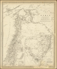
Fine 19th-century map of the Arabian peninsula, showing modern detail with cities, mountains, plains and more shown. Detail in the interior of the continent is sparse.
The map extends all the way to the Mediterranean Sea, shows the Arabian coastline, and the Persian Gulf is so named.
This map was published by Thomas Tegg and Company in London.
Condition Description
Original hand-color.

![[ Arabian Peninsula ] Tabula Asiae VI](https://storage.googleapis.com/raremaps/img/small/65903.jpg)
![[Hand-Drawn Map Showing the Extent of the Ottoman Empire]](https://storage.googleapis.com/raremaps/img/small/99654.jpg)
