|
||

|

|
|

|
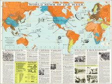
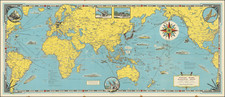
Very Rare French Propaganda Poster from the Second World War
Fantastic map of the world, highlighting historical military and explorational successes of French citizens. The map was published by the Vichy French government for French youth during the middle of the Second World War in the then-unoccupied zone of France.
The map seeks to convey a sense of French national identity at a very complicated time in the political situation of France. Marechal Petain and the Vichy Government sought to reestablish French strength by collaborating with the fascist regimes of Europe. The complicated government messaging explained this collaborationism by pushing forward a pro-European, colonial, and anti-British agenda, which it was hoped would help France regain lost power.
The map depicts dozens of historical events, and names all current French colonies in red, and former French colonies (mostly in the Americas) in grey, and the map is most certainly pro-colonial and anti-British. The death of Montcalm outside Quebec is shown heroically, as he is shown defending the city from the British. The map makes many other sly references to French activity in North America. Curiously, no expansionary activity in the rest of Europe is shown. This can be easily explained by the long history of French-German animosity, a topic that would have been taboo here, as well as the Vichy Government's policies of European unity.
Few twentieth-century references appear on the map, with the notable exception of the 1940 Battle of Dakar, led by British troops against French forces in Senegal. This inclusion shows how the current actions of the French government were simply a continuation of over a thousand years of military exploits, and the map encourages French youth to take up the historical greatness of their country in the current fight against England.
The "Free Zone" in 1942
This map was published in Lyon, then-part of the "Free Zone," or the zone controlled by the Vichy Government. The collaborationists governed land roughly south and east of the German army's furthest advance during the Battle of France and was led by the World War I military hero, Marechal Philippe Petain.
The Vichy Government sought to reestablish France as a leading world power by realigning their allegiances into a pro-German, anti-Communist, and anti-English alliance. The government's policies were nationalistic and bordering on fascist, and the French propaganda machine tried to support family policies, nationalism, and social Darwinism. The message in the cartouche on the present map reflects the second of these:
"Inheriting such magnificent patrimony and in front of vast horizons, does a young French person have the right to doubt in himself and in the future of France?"
1942 would be the final year of any sort of French sovereignty. While the Vichy government persisted until the end of the war, German troops invaded the "Free Zone" in November of 1942 as part of Operation Attila, following the defection of North African French troops. After the invasion, life for French citizens became substantially more difficult, with forced work programs and numerous deportations.
Rarity
We were only able to trace a single other example of this map, at Washington State University.