|
||

|

|
|

|
Stock# 78034
Description
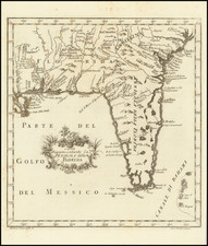
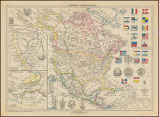
An Early Mapping The Gulf Stream
Fine large map of the South Florida, the Bahamas and the Caribbean, based upon Bryan Edwards map of the region issued in 1793.
The map extends from South Florida,the Bahamas (or Lucayos) and the Florida (Gulf) Stream and the Bahamas in the north to the Yucatan, Mosquito Coast, Windward Islands and the Guyanas in the southeast.
The treatment of the inland river system and massive "Spiritu Santu" Lake (or Lagoon) provides a fascinating early depiction of Lake Okeechobee.
In addition to the Gulf Stream, other arrows show the prevailing currents in both the Atlantic and the Caribbean Sea.