|
||

|

|
|

|
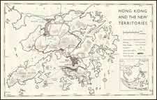
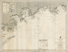
Published in the year in which the People's Republic of China was founded, this map shows the border between the British-ruled territory of Hong Kong and mainland China. This War Office map shows a four-color representation of the western half of the aforementioned border.
With British military precision, this survey map shows topography on land and underwater, the extent of marshes, the courses of rivers, and the amount of built-up land. A legend appears at the bottom of the map.
This map is based on several surveys dating from the period 1924-1939, which was shortly followed by the occupation of the city by Japanese imperial forces. The period around 1949 saw a massive influx of immigrants fleeing Communist rule, which would have crossed the land border shown here. Shenzhen, which now occupies the region shown, would grow massively and is now a city of over seventeen million.
![[ Hong Kong / Macao / Canton ] Iunnan, Queicheu, Quangsi et Quantun, Provinciae Regni Sinensi Praefecturae dictae](https://storage.googleapis.com/raremaps/img/small/55800.jpg)