|
||

|

|
|

|
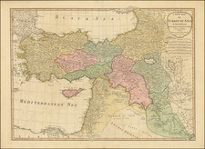
Foreshadowing The Great Game -- A Monumental Map of The Region Between Istanbul and Delhi
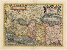
Rare deluxe full original color example of this finely executed wall map, extending from Istanbul to China, and from the eastern Mediterranean to the Himalayas, respectively, including Egypt, northern Saudi Arabia, the Levant, Georgia and Armenia, Persia, western China, and northern India, published in London by Aaron Arrowsmith.
The map was intended as an exhaustive treatment of the overland route to India from Europe, and an overview of the ever-precarious northwestern border of British India. The map portends the Great Game, the struggle between Russia and the British Empire for Central Asia, which began with the establishment of an Anglo-Indian trade route to the Emirate of Bukhara (on this map "Bokhara") in 1830.
The map is also remarkable for its treatment of the Middle East on the eve of the first modern surveys of the region.
Middle East Cartography
The cartographic detail in the Middle East is considerable for a map of 1816.
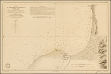
In what would become the United Arab Emirates, the territory is labeled "Joasmi Arabs" with the following toponyms: "Aboo Heyle" (i.e., Abu Hail, Dubai), "Sharga" (Sharjah), "Fusht", "Aymann" (Ajman), Murgaveen, Rasool Khyma (Ras Al Khaimah), Calba, and Ras Ollima. The map was published only three years before the British government in India launched the Persian Gulf campaign of 1819, which subdued the Al Qasimi naval forces (and their alleged piratical activities) and resulted in the General Maritime Treaty of 1820 and the establishment of the "Trucial Coast".
On the peninsula of Qatar, "Ras Reccan", "Yamale" (Al Jumail), "Agulla", "Core Hessan" (Al Khuwayr), and "Fereyha" are shown.
Although crude by modern standards, the mapping of the Gulf was some of the best available to the British before George Barnes Brucks' first English survey of the Gulf in 1820.
The map includes important anthropological information in the form of numerous specific ethnonyms sprinkled throughout the Middle East. In present-day Iraq there are "Irak Arabi", "Montefidge Arabs", and "Montesik Arabs" north there is "Kourdistan", across the Syrian Desert there is "Ilaouari Arabs", "Anase Bedouins", "Serde Arabs", "Maouli Bedouins", and "Sakr Arabs".
Grane, the original fishing village of the Sheikhdom of Kuwait is shown with a road to Basra.
Trade and Caravan Routes
In keeping with a map intended to show overland travel, the map is crisscrossed with a web of trade and caravan routes, many of which are annotated. The notes concern days required to traverse the routes (e.g., "35 Days Reported time for the Pilgrims from Medina to Schah Haffer") and, importantly for this region, the places where water could be obtained (e.g., "Well of Good Water | Here Water is provided for 6 Days"). In Persia, the nature of the caravans is elaborated -- "Forty days Journey from Yezd to Furrah for laden Camels" and "Thirty days Journey from Yezd to Dooshak for laden Camels." Other routes noted include:
- From Kerman to Herat across the Desert a Courier can go in 18 days
- Ancient Road of the Nagais from Guriev to Urgantz
- Route of Messers Hogg and Thompson in 1741
- Route of the Caravan from Orenburg to Backharaand and Chiva
- Route of the Caravan from Orskaja to Bakhara
- 8 days from Cashmere
- 8 Days for a Kasila at 7 Coss a day
- It is said the Wool for making Shawls is brought from Rodack and Channtre by way of Leh to Cashmere on Sheep. It is reckoned 25 days Journey to the Leh River
- Bearing of Guinnak Capital of Chinese Tartary reported 20 days Journey
Arrowsmith was apparently quite careful with the routes he noted; there is evidence of an erased route through the central Arabian Peninsula that was clearly present on the 1814 edition, but which has been obliterated here.
Conclusion
This is a highly unusual Arrowsmith map - at around 10 feet wide, it is among the largest mappings of a region undertaken by Arrowsmith. Additionally, the subject matter was often neglected by other mapmakers of the era, and so this map is indispensable for understanding the British disposition in the 19th-century geopolitical confrontations in Western Asia and the Middle East.
The map is characteristic of the masterwork that we expect from Aaron Arrowsmith; it is impressive in scale, authoritativeness, and detail. And like with his famous map of Africa, he has dispensed with that information which could not be reliably confirmed.
Deluxe Presentation
The map is extremely rare. When it does appear on the market, it is normally found in simple outline color, as seen here: https://www.raremaps.com/gallery/detail/60677
The present example is in full wash color, with full green silk edges, and include a finely crafted full leather case. It also bears an unusual booksellers plate, "Black, Parbury & Allen, Booksellers To the Honble. East India Company, Stationers, Map and Chart Sellers, 7 Leadenhall Street (Watts' Copying Machines)." (top and bottom right corners).
We surmise that the prior owner was likely of noble descent or high military rank.
Provenance
Black, Parbury & Allen, Booksellers To the Honble. East India Company. Sothebys, 1964. Sold to Maggs Brothers. Also possibly Francis Edwards, 1978.
Rarity
The map is very rare. We locate the following examples:
1814: Oxford; Bibliotheque National de France; Wurttembergische Landesbibliothek; University of Minnesota; University of Melbourne.
1816: Rumsey/Stanford Copy - sold by this firm in 2019.
1817: Bibliotheque National de France
1821: British Library
We note only one other example at auction since 1980 (Bloomsbury, 2008). We previously offered an example of the 1816 edition in 2019 (uncolored), now in the David Rumsey / Stanford Collection.
The Arrowsmiths were a cartographic dynasty which operated from the late-eighteenth century to the mid-nineteenth. The family business was founded by Aaron Arrowsmith (1750-1823), who was renowned for carefully prepared and meticulously updated maps, globes, and charts. He created many maps that covered multiple sheets and which were massive in total size. His spare yet exacting style was recognized around the world and mapmakers from other countries, especially the young country of the United States, sought his maps and charts as exemplars for their own work.
Aaron Arrowsmith was born in County Durham in 1750. He came to London for work around 1770, where he found employment as a surveyor for the city’s mapmakers. By 1790, he had set up his own shop which specialized in general charts. Arrowsmith had five premises in his career, most of which were located on or near Soho Square, a neighborhood the led him to rub shoulders with the likes of Joseph Banks, the naturalist, and Matthew Flinders, the hydrographer.
Through his business ties and employment at the Hydrographic Office, Arrowsmith made other important relationships with Alexander Dalrymple, the Hudson’s Bay Company, and others entities. In 1810 he became Hydrographer to the Prince of Wales and, in 1820, Hydrographer to the King.
Aaron Arrowsmith died in 1823, whereby the business and title of Hydrographer to the King passed to his sons, Aaron and Samuel, and, later, his nephew, John. Aaron Jr. (1802-1854) was a founder member of the Royal Geographical Society (RGS) and left the family business in 1832; instead, he enrolled at Oxford to study to become a minister. Samuel (1805-1839) joined Aaron as a partner in the business and they traded together until Aaron left for the ministry. Samuel died at age 34 in 1839; his brother presided over his funeral. The remaining stock and copper plates were bought at auction by John Arrowsmith, their cousin.
John (1790-1873) operated his own independent business after his uncle, Aaron Arrowsmith Sr., died. After 1839, John moved into the Soho premises of his uncle and cousins. John enjoyed considerable recognition in the geography and exploration community. Like Aaron Jr., John was a founder member of the RGS and would serve as its unofficial cartographer for 43 years. Several geographical features in Australia and Canada are named after him. He carried the title Hydrographer to Queen Victoria. He died in 1873 and the majority of his stock was eventually bought by Edward Stanford, who co-founded Stanford’s map shop, which is still open in Covent Garden, London today.
![[Poster] Keep the Promise The Israel Emergency Fund](https://storage.googleapis.com/raremaps/img/small/78786.jpg)