This item has been sold, but you can enter your email address to be notified if another example becomes available.


|
||

|

|
|

|
Stock# 77968
Description
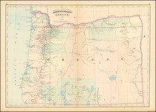
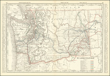
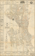
Attractive vintage pictorial map of the Pacific Northwest. The map focuses on the highways of the region, with detail provided on towns, cities, and points of interest.
Detail on the map extends as far as Glacier and Yellowstone National Parks to the east, claiming that they are contiguous to the Pacific Northwest. Many images are printed on the verso, with accompanying descriptions.
The map provides little evidence to dating, though the style, language, and depictions of cars suggests a 1920s or 1930s publication.
Condition Description
Folding map. Printed recto-verso. Small hole at fold intersection.
![Camp Pendleton [cover:] Two Weeks With The Marines in California](https://storage.googleapis.com/raremaps/img/small/92525.jpg)