
This item has been sold, but you can enter your email address to be notified if another example becomes available.


|
||

|

|
|

|
Stock# 77954
Description
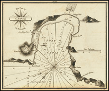
Attractive antique map of the town immediately west of Cannes, Antibes, on the French Riviera. This fabulous maritime sea chart shows the city with its walls, depth soundings, the harbor, and other coastal details along the Cap d'Antibes.
Luffman's Select Plans is an uncommon traveler's guide that served to educate the intrepid traveler regarding any part of the world, from the major cities of Europe to the wild coasts of the Spice Islands. Each of Luffman's maps contained detailed coastal descriptions showing the major landmarks and cities, as well as basic but necessary navigational information. This plate appeared in the second of Luffman's two volumes.
Condition Description
Original hand-color.
![[ South France ] The South Eastern Part of France which includes Roussillon-Languedoc, with a Great Portion of Rouergue and Auvergne-Provence-Dauphine, and the Whole Frontier of Italy](https://storage.googleapis.com/raremaps/img/small/102796.jpg)
![Disegno Particolare del Piemonte et Monferrato e suoi confini [Detailed Map of Piedmont and Monferrato and their boundaries.]](https://storage.googleapis.com/raremaps/img/small/75464.jpg)
![[Monaco] Carta Topografica del Principato di Monaco](https://storage.googleapis.com/raremaps/img/small/86346.jpg)