


|
||

|

|
|

|
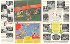
Unrecorded Early New Yorker's View Pictorial Map
Rare (previously unknown?) early pictorial map of the United States, drawn by David Wallingford.
The map provides a marvelous whimsical view of the United States, placing certain states as cities inside of other states (Idaho is a city in Oregon, Nebraska is in Illinois, etc.), cities and other locations misplaced within states (Ottumwa and Yellowstone in Colorado, Denver in Utah, Little Rock and Kansas in Missouri, Tulsa in Arkansas, etc.) and a few completely fanciful states (Hollywood and San Francisco). A number of neighboring Islands are also whimsically distorted.
The present map would seem to be the earliest draft version of Wallingford's map, which would later be modified to create the 3 sizes of Wallingford maps which were published beginning in about 1935. It would appear that after the printing of this 1932 map, Wallingford removed the text/title border, added captions and slightly revised the original artwork, before releasing the map for sale. In a letter from Wallingford dated September 2, 1935 in the David Rumsey collection, he promotes a revised edition of the map in 3 sizes, 8.5 x 6.5 inches, 12.5 x 10 inches, and 20 x 15 inches.
The present example may be one of the 100 examples printed by Wallingford as Christmas gifts in 1932 or somehow related thereto.
Wallingford began publishing pictorial maps while working as an industrial designer and artist after World War II. He is best known for his New Yorker's View of the United States of America and The Bostonian's View of the United States of America.
Rarity
We are unable to locate another example of the map.
This example is one of three acquired in September 2020 from a collection which included a number of other pictorial maps from the same time period, which may have been assembled by a merchant who was selling these pictorial maps in the 1930s.

![[Montana - Helena National Forest] Howdy & Welcome to Helena in the Heart of the Gold Country](https://storage.googleapis.com/raremaps/img/small/97044.jpg)