|
||

|

|
|

|
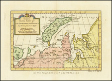
With A Spectacular Early View of Prince William Sound
Rare illustrated map of the Northwest Coast of America and Northeast Coast of Asia, which appeared in the first German edition of the official account of Cook's Voyages.
The map tracks the progress of Cook's Voyage through the region and includes a fantastic view of Snug Corner Harbor in Prince Williams Sound.
The coastline is well presented with hachure showing mountains, sections of coastlines and islands with place names and soundings. The tracks of the 1778 and 1779 exploration are shown, Cook having done the former and Clerke the latter after Cook's death in Hawaii in Feb. 1779.
The unknown / unexplored regions of the coast are treated with dotted line, and include the area between Nootka Sound and Cape Flattery (entrance to the Straits of Juan de Fuca), and includes a section further south near Cape Foulweather and Cape Gregory, in the area near Yaquina Bay, Oregon.
The maps from the German edition are very rare on the market and the only edition to include illustrations on the map.
![[Alaska to San Diego and San Qunitin, British Columbia] A Chart Shewing Part of the Coast of N.W. America, with the Tracks of His Majesty's Sloop Discovery and Armed Tender Chatham . . . (First Modern Map of the West Coast of North America)](https://storage.googleapis.com/raremaps/img/small/102067.jpg)
![[ Chinese Voyages To America, etc. ] Memoires De Litterature, Tires Des Registres De L'Academie Royale Des Inscriptions et Belles-Lettres Depuis l' annee M. DCC. XVIII. julques & compris l'annee M. DCC. XXV Tome Quarante-Neuvieme](https://storage.googleapis.com/raremaps/img/small/101296.jpg)