
![[ Baja California ] By James Burney](https://storage.googleapis.com/raremaps/img/small/85440.jpg)


|
||

|

|
|

|
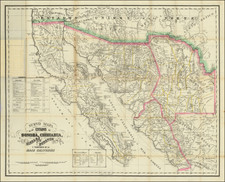
Very Rare Map of Baja California
Scarce atlas map of Baja California, naming San Diego and showing the Channel Islands as well as the course of the Colorado River. This map originally appeared in the important A Chronological History of the Discoveries in the South Sea or Pacific Ocean.
The map shows fine detail throughout Baja California, the Gulf and western Mexico. The map stretches down to the northernmost part of Jalisco State, and shows a number of coastal cities and the mouths of rivers. In the northern part of the map, the Upper Colorado is still referred to as the Rio del Norte, and the B. de S. Pedro is named where Los Angeles would later appear.
Burney's History is considered the "most important general history of the early South Sea discoveries" (Hill). Having established himself during Cook's second and third voyages, Captain Burney was considered the authority of his time on the voyages to the south sea. This work was critical to compiling our early understanding of the last voyages of discovery. This map of Baja helped to cement our understanding of this peninsula, less than a century after it was accepted that California was, in fact, not an island.
This chart is rare on the market. This is the first time we have handled the map.
![Parts of E. California and S. E. Nevada, N.W. Arizona and S.W. Utah __ Atlas Sheet No. 66 [Shows Las Vegas!]](https://storage.googleapis.com/raremaps/img/small/92030.jpg)
![Lands of the Hemet Land Co. [Hemet Southern California. Its homes and scenes]](https://storage.googleapis.com/raremaps/img/small/89106.jpg)
![[ Hungarian Traveler In the California and the West with a Comanche and Wichita to Hungarian vocabulary ] Levelei Éjszakamerikából -- Tizenkét eredeti rajzok után készült kő- és egynéhány fametszettel. Közli Prépost István (Letters from North America)](https://storage.googleapis.com/raremaps/img/small/98502.jpg)