
The item illustrated and described below is sold, but we
have another example in stock. To view the example which
is currently being offered for sale, click the
"View Details" button below.


|
||

|

|
|

|
Stock# 77889
Description
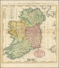
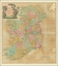
One of the first maps of Ireland Printed in America
Interesting map of Ireland, hand colored by counties.
Shows towns, roads, rivers, lakes, mountains, Islands, bays, points, etc. 32 counties named.
From the 1814 edition of Carey's General Atlas, one of the earliest large format atlases published in America. The map is among the earliest maps of Ireland printed in America.
Condition Description
Minor toning.
![[Ireland / Sea Chart] Carte des Cotes Occidentales D'Irlande Reduite de la Carte de Stuart Amos Arnold et rectifee d'apres les Plans leves par M. MacKenzie Publiee Par ordres du Contr-amiral Decres Ministre de Marine et des Colonies . . . 1803](https://storage.googleapis.com/raremaps/img/small/63682.jpg)
![[Northwest Ireland] De West-Cust van Yerlandt tusschen C. Tellin en Slijnehooft](https://storage.googleapis.com/raremaps/img/small/75344.jpg)
![[Hungarian Map of Great Britain] Nagy Britannia](https://storage.googleapis.com/raremaps/img/small/85219.jpg)
![(British Isles) Tabu Moder Anglie & Hiber [Modern Map of England and Ireland]](https://storage.googleapis.com/raremaps/img/small/103164.jpg)