|
||

|

|
|

|
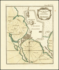
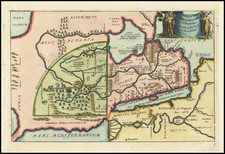
Attractive original antique sea chart of the port of Alexandria at the edge of the Nile Delta. The map shows the new city, the site of the old city, lighthouses, and depth soundings.
The layout of the port of Alexandria has allowed for the long-term survival of the city. Rare tsunamis caused by mega slip earthquakes in Malta have the potential to devastate much of the Egyptian coastline, but the spit of land with the Great Lighthouse protects Alexandria.
Luffman's Select Plans is an uncommon traveler's guide that served to educate the intrepid traveler regarding any part of the world, from the major cities of Europe to the wild coasts of the Spice Islands. Each of Luffman's maps contained detailed coastal descriptions showing the major landmarks and cities, as well as basic but necessary navigational information. This plate appeared in the second of Luffman's two volumes.
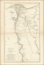
![Egypt called in the Country Missir by Monsr. D'Anville of the Royal Academy of Belles Lettres, & of that of Siciences [sic] of Petersburg Secretary to H.S.H. the Duke of Orleans. MDCCLXV.](https://storage.googleapis.com/raremaps/img/small/49130.jpg)