|
||

|

|
|

|
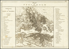
Decorative antique engraved bird's-eye view of Stockholm from across the harbor, published in 1700. The view shows buildings, churches, bridges, ships, docks, the fortified walls of the city, and the surrounding area. The king's palace and St. Gertrude's Church are both labeled.
During this period, Sweden was becoming one of the leading powers of Europe, and this is reflected in the expansion and construction of the city. This view preserves Stockholm before significant expansion. The city is mostly limited to the central island of the Stockholm archipelago, though some houses are built on surrounding islands and the mainland. This map shows the city immediately after a fire that destroyed much of Tre Kronor, along with Sweden's historical archives, in 1697.
This view was published by Pierre Aveline, one of the foremost viewmakers of the first part of the 18th century.

![[ Norway and Sweden ] Septentrionalium Regionum Suetiae Gothiae Norvegia Daniae](https://storage.googleapis.com/raremaps/img/small/67558.jpg)