


|
||

|

|
|

|
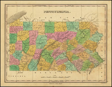
Stock# 77862
Description
Scarce Revolutionary War-period map of Pennsylvania, depicting settlements and roads as well as topography.
The map extends as far west as Chambers Town in Pennsylvania and includes part of New Jersey. The Boundary Line of Philadelphia that was surveyed in 1730 divides Pennsylvania from Maryland.
The map includes a decorative title cartouche with a fort and canon.
Condition Description
Right margin trimmed to the neatline at the lower-right, as issued. Small tab tear.
Reference
Jolly UNIV-185; Sellers and Van Ee #1298.
![[ Virginia / Maryland / Chesapeake Region ] Pas Kaart van de Zee Kusten van Virginia Tusschen C. Henry ent Hooge Land van Renslaars Hoek. . .](https://storage.googleapis.com/raremaps/img/small/47255.jpg)
![[ Pennsylvania Manuscript - Thomas Vickroy Surveys in Bedford (now Somerset) County] (Four maps on 1 sheet)](https://storage.googleapis.com/raremaps/img/small/83404.jpg)
![1794 Land Survey Signed by Alexander McDowell D[eputy] S[urveyor]](https://storage.googleapis.com/raremaps/img/small/101014.jpg)