|
||

|

|
|

|
Stock# 77812
Description
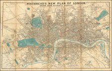
Attractive original antique map showing the heart of London's City. The map shows the area just west of Aldgate and just outside the city's old walls, comprising an area that contains some of the most important financial market centers.
Detail on the plan is extensive, with the outlines of buildings drawn and many streets, lanes, and alleys all depicted. Churches are shown pictorially and a view of Leaden Hall is shown above the map.
The map is dedicated to the alderman of Limestreet Ward, John Porter. His coats of arms are shown in the upper right of the map.
The map was engraved for Maitland's Survey of London, which showed London in the middle of the 18th century and for which Cole engraved numerous maps.
![[ London ] An Exact Survey of the City's of London Westminster ye Borough of Southwark and the Country Near Ten Miles Round Begun In 1741 & Ended in 1745 By John Rocque Land Surveyor & Engrau'd By Richard Parr / A New and Accurate Survey Of the Cities of London and Westminster The Borough of Southwark with The Country about it for nineteen Miles in Length and thirteen in Depth . . .](https://storage.googleapis.com/raremaps/img/small/96431.jpg)