


|
||

|

|
|

|
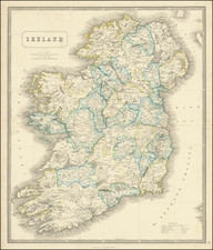
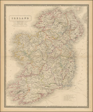
Large, detailed engraved folding map of Ireland, published in the middle of the 19th century, by London-based mapmaker George F. Cruchley. The map had been published by John Cary, prior to Cruchley taking over its publication.
The map shows Ireland hand-colored by county, with an additional line of coloring at the county borders a certain distance from Dublin. Many other points of interest are noted on the map, including hundreds of towns, roads, mountains, etc.
Cruchley moved his premises to 81 Fleet Street, London, in 1834. The estimated date is perhaps too early, however, the use of John Cary's name to promote the map suggests it was closely posthumous (Cary died in 1835). This, combined with the address, leads us to the conclusion that the map was published reasonably soon after Cruchley got the plate from Cary's estate.
Cary's version can be seen here: www.raremaps.com/gallery/detail/77787
![[Hungarian Map of Great Britain] Nagy Britannia](https://storage.googleapis.com/raremaps/img/small/85219.jpg)
![[ Ireland ] Hyberniae Regni in Provincias Ultoniam, Connachiam, Lageniam, Momoniamq divisi Tabula Accuratisima editore Covens et Mortier Amstelo-Batavio](https://storage.googleapis.com/raremaps/img/small/99667.jpg)