|
||

|

|
|

|
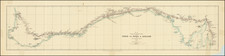
Showing the Expedition that Lead to the Foundation of Geraldton
Fantastic rare map of Western Australia, showing the discoveries made during the final voyages of John Septimus Roe, one of the great surveyors of the region.
This plate, published as part of an expedition report presented to the Royal Geographical Society, includes two maps. The larger of the two maps shows the route taken by Roe during an extremely arduous five-month voyage from Perth eastwards to the Russell Range. Leaving Perth in November of 1848, the group headed eastwards along the Avon Branch of the Swan River, before swinging south towards Bremer Bay. The group then proceeded to the Russell Range, and then returned to Perth along the coast.
The ancillary map shows an 1848 expedition led by Governor Fitzgerald northwards to just shy of Shark Bay in search of a "new tract of good land." Another expedition lead by Arthur Charles Gregory was sent to explore the Gascoyne River, which it appears not to have reached. However, on this route Gregory discovered lead ore near the coast, which led to the discovery of the Geraldine Mine and eventually the town of Geraldton.
Rarity
This map is rare on the market. We have never offered it for sale before.
Surveyor General John Roe
John Roe led a distinguished career as Surveyor General of West Australia from 1829 until his retirement in 1871. His prolific period of leading expeditions to map and discover the interior of the territory started the year of his appointment with an expedition up the Swan River.
His last expedition would be his trip to the inland Russell Range, completed in 1848 and 1849. This trip was particularly notable for the exploration of new coal seams as well as his detailed geological reporting of the interior of the continent.
![(Australia) Australien - Ubersicht des Standpunkets der geographischen Kenntniss von Australien, 1868, & Dr. Neumayer's Projeket zur wisseschaftlichen Erforschung Central-Australiens [Survey of the Standpoint of the Geographical Knowledge of Australia, 1868, & Dr. Neumayer's project for the scientific investigation of central Australia]](https://storage.googleapis.com/raremaps/img/small/85398.jpg)