|
||

|

|
|

|
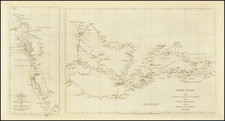
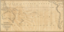
The Discovery of the Western Australian Interior
Nice original antique map showing the explorations of the Alexander Forest expedition to the Hampton Plains of Western Australia, undertaken in the winter of 1871. This map was published in London in 1872 by the Royal Geographical Society in order to illustrate the discoveries of the expedition.
The map shows Western Australia from Perth inland eastwards to the Great Bight. Annotated are the tracks of Forrest's voyages as he initially traveled eastwards to the interior of the continent, before swinging south to the coast. Nightly resting points, water, and other features are shown.
The six-person Forrest expedition made it to the region around Lake Lefroy with the goal of finding a pastoral country. While initially optimistic, the many dried and salt lakes of the region were not as useful as initially thought and as shown on the map. A return expedition in 1876 would diminish any excitement for the potential of the Hampton Plains.
![[Melbourne, Australia] We show you Melbourne City, but from a dizzy height. Come see it as we know it, you'll vote it very bright!](https://storage.googleapis.com/raremaps/img/small/94298.jpg)