|
||

|

|
|

|
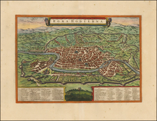
Full wash color example of this rare decorative plan of Rome, published in Leiden by Halma and van der Aa.
This fine map of Rome is based on Giovanni Battista Falda's influential 12-sheet wall map, published in 1676. It provides remarkable detail down to the streets, churches, houses, gardens, piazzas, bridges and gates with the Vatican appearing in the immediate foreground. The legends flanking the map contain a key to 473 locations.
The City on Seven Hills is encompassed by its ancient walls and the banks of the River Tiber. Numerous monuments and sites, all of which are still present today, can be seen on the view, including the Coliseum, the Pantheon, the Piazza del Popolo, the Church of San Giovanni Laterno, the Castel Sant'Angelo and the Vatican, which is dominated by the Dome of St. Peter's Basilica and Gianlorenzo Bernini's great oval Colonnade that lines the square below.
Many allegorical renditions appear throughout the map. St. Peter is shown holding a large gold key, the figure of justice appears, and various figures in Roman dress abound. In all, a very nice map.
Pieter van der Aa (1659-1733) was a Dutch mapmaker and publisher who printed pirated editions of foreign bestsellers and illustrated books, but is best known for his voluminous output of maps and atlases. Van der Aa was born to a German stonecutter from Holstein. Interestingly, all three van der Aa sons came to be involved in the printing business. Hildebrand was a copper engraver and Boudewyn was a printer.
![[Rome / Controlling The Tiber River] Parer di Gio Paolo Maggio Archit Sopra l'inondation di Roma](https://storage.googleapis.com/raremaps/img/small/85891.jpg)
![[ Ostia - Old Port of Rome ] Utriusque Portus Ostia Delineatio -- Amplis Prudentis Domino Cornelio Witzen Urbis Amsteledamensis Consuli ac Senatori, Nuper in fupremo rei maritime Concilio ibidem Delegato, Tabula hane D.D. J. Blacu](https://storage.googleapis.com/raremaps/img/small/102613.jpg)
![Veduta della Fornice dé Consoli Dolabella, e Silano, investita dagli Archi Neroniani provenienti dal Condotto dell'Aqua Claudia [View of the Arch of the Consuls Dolabella and Silanus, Overwhelmed by Nero's Arches Originating from the Aqua Claudia Conduit.]](https://storage.googleapis.com/raremaps/img/small/92280.jpg)
![(Rome) Il Prospetto della Città Leonina, che si vede colla Basilica Vaticana, Ponte, e Castel S. Angelo [The View of the Leonine City, with the Vatican Basilica, Bridge, and Castel Sant'Angelo]](https://storage.googleapis.com/raremaps/img/small/93193.jpg)