|
||

|

|
|

|
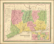
One of the First Maps of Connecticut Published in Europe
Fine example of this rare map of Connecticut, drawn from the map of Carey & Lea.
Shows early towns, townships, roads, rivers, mountains, lakes, and other geographical features. The road details are quite noteworthy.
One of the few non-American published maps to show Connecticut's townships.
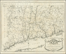
Carey & Lea published the Atlas of North America in 1822. The atlas was a commercial success and was re-issued in 1823 and 1827. A French edition of the Atlas was published by Buchon in Paris in 1825. This German edition by Weiland is by far the rarest.
All of the maps have been re-engraved by the Weimar Geographischen Insitut, a well regarded cartographic publisher. The engraving quality of the maps far surpasses the American edition. Weiland actually added several maps which did not appear in the Carey & Lea or Buchon additions.