


|
||

|

|
|

|
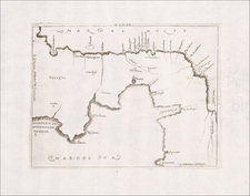
A Meticulous Accounting of the Boundaries in Central America
Rare, late variant of Wyld's map of Central America, focusing on the boundaries of the various Central American states and colonies.
While the map appears similar to earlier states issued between 1850 and 1852, it includes extensive revisions. Chief among these is the addition of a key to 23 different border claims and changes, some topographical updates, and additional place names. There is a table of possible routes across the isthmus, a major engineering and navigational concern of the later nineteenth century.
The map shows the region in striking detail, stretching from southern Mexico to El Salvador, Honduras, Mosquitia (Belize), Nicaragua, Costa Rica, and New Granada (including Panama).
Central America in the colonial and independence eras
Imperial control of areas of Central America changed rapidly, as did the borders when various areas began to declare their independence. Initially, Spain nominally controlled most of the area, an extension of their viceroyalties of New Spain and the audiencia at Santa Fé de Bogotá. From the sixteenth century, the area was controlled by the Captain Generalcy of Guatemala, which stretched from Chiapas to Costa Rica.
However, Britain formally gained recognition of their settlement of part of the coast of Honduras, today Belize, in the late eighteenth century. Additionally, many areas were outside of official control, with communities of maroons (runaway enslaved peoples), pirates, contraband traders, Afro-Indians, and loggers making their homes in the region.
The Age of Revolutions did not skip over the area. In 1811, El Salvador started its own independence movement as a reaction to the Peninsular War that was roiling Spain. Another rebellion broke out in 1814, at the restoration of Ferdinand VII. In 1821, creole politicians in Guatemala City declared the entire region’s independence, but it was quickly subsumed in Agustín de Iturbide’s independent Mexico. This was undone on July 1, 1823, when Central America declared the Absolute Declaration and eventually formed the United Provinces of Central America (UPCA) consisting of Guatemala, El Salvador, Honduras, Nicaragua, and Costa Rica. Belize remained under the control of Britain until 1981.
Although formally a republic, local dissent and disagreements caused fragmentation quickly. Quetzaltenanago, in Chiapas, was added in the 1830s. Civil war broke out in 1838, crumbling the UCPA. Another attempt at unification happened in the early 1840s, and another attempt was made in late 1852.
Grey Town, or San Juan del Norte
While most of the political entities on this map would be familiar, there is one feature that might be new: Grey Town. Originally called San Juan del Norte, the settlement was founded by the Spanish in 1539. In 1707, the area was captured by a coalition of Miskitos, Afro-Indians, and English. They returned in 1762. Spain reasserted control after the 1786 Convention of London, but they were ousted in 1821 when Central America became independent.
In 1841, the British-backed Miskitos took the town. Seven years later, the British themselves occupied it and renamed it Greytown after the Jamaican Governor, Charles Edward Grey. In only a year, the town boomed when it became the eastern terminus of Cornelius Vanderbilt’s Accessory Transit Company. This was a precursor to the Panama Canal, a boat and mule route transporting travelers from Atlantic to Pacific in search of gold in California.
In 1854, the USS Cyane sailed into the harbor. It bombarded the settlement, burning it to the ground, supposedly in retaliation for the mistreatment of American citizens. In actuality, the mistreatment was a dispute about tariffs and the transit route. The town was again destroyed when the San Juan River changed direction.
In 1855, William Walker, an American, declared himself the President of Nicaragua. He seized control of the Accessory Transit Company’s assets, revoking its charter in the process. Vanderbilt was incensed and sent a private army to deal with the interloper. Walker was dispatched in 1857, just after the publication of this map. Walker tried to return in late 1857, but U.S. Marines captured him.
James Wyld Sr. (1790-1836) was a British cartographer and one of Europe’s leading mapmakers. He made many contributions to cartography, including the introduction of lithography into map printing in 1812.
William Faden, another celebrated cartographer, passed down his mapmaking business to Wyld in 1823. The quality and quantity of Faden’s maps, combined with Wyld’s considerable skill, brought Wyld great prestige.
Wyld was named geographer to Kings George IV and William IV, as well as HRH the Duke of York. In 1825, he was elected an Associate of the Institution of Civil Engineers. He was one of the founding members of the Royal Geographical Society in 1830. Also in 1830, his son, James Wyld Jr., took over his publishing house. Wyld Sr. died of overwork on October 14, 1836.
James Wyld Jr. (1812-87) was a renowned cartographer in his own right and he successfully carried on his father’s business. He gained the title of Geographer to the Queen and H.R.H. Prince Albert. Punch (1850) described him in humorous cartographic terms, “If Mr. Wyld’s brain should be ever discovered (we will be bound he has a Map of it inside his hat), we should like to have a peep at it, for we have a suspicion that the two hemispheres must be printed, varnished, and glazed, exactly like a pair of globes.”
![[Portobelo, Colon, Panama] Portus Pulchri in Isthmo Panamensi ... [on sheet with] Scenographia Portus Pulchri ...](https://storage.googleapis.com/raremaps/img/small/89442.jpg)
![Carte Des Antilles Du Golfe Du Mexique et d'une partie des Etats voisons…1842 [Republic of Texas]](https://storage.googleapis.com/raremaps/img/small/98848.jpg)