


|
||

|

|
|

|
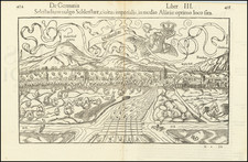
Striking view of Colmar and vicinity, from Munster's Cosmographia, first published in 1544.
Interesting woodblock view of Colmar in Alsatia on the Lauch River, the a part of Germany but currently a part of France. This town lies on the Oder River, on the modern border between Germany and Poland. Individual landmarks and buildings are named as well as farms and other points of interest in the surrounding countryside.
Colmar was founded in the 9th century and granted the status of a free imperial city of the Holy Roman Empire in 1226. In 1575, the city adopted the Protestant Reformation, long after the northern neighbors of Strasbourg and Sélestat. During the Thirty Years' War, the city was taken by the armies of Sweden in 1632, who held it for two years. The city was conquered by France under Louis XIV in 1673.
As part of the Treaties of Nijmegen in 1679, Colmar and all of Alsace were ceded to France. In 1871, along with the rest of Alsace, it was annexed by the newly formed German Empire in 1871 as a result of the Franco-Prussian War. It returned to France after World War I, was annexed by Nazi Germany in 1940, and then reverted to French control after the battle of the "Colmar Pocket" in 1945.
Munster's Geographia (first published in 1540) and his later Cosmographia were cartographic landmarks. The Geographia included not only Ptolemaic maps, but also a number of landmark modern maps, including the first separate maps of the 4 continents, the first map of England and the earliest obtainable map of Scandinavia. The Cosmographia (first published in 1544) was the earliest German description of the world and a major work in the revival of geographic thought in 16th-century Europe. Altogether, about 40 editions of the Cosmographia appeared between 1544 and 1628.
Munster dominated cartographic publication during the mid-16th Century. Munster is generally regarded as one of the important map makers of the 16th Century. Munster was a linguist and mathematician, who initially taught Hebrew in Heidelberg. He issued his first mapping of Germany in 1529, after which he issued a call geographical information about Germany to scholars throughout the country. The response was better than hoped for, and included substantial foreign material, which supplied him with up to date, if not necessarily accurate maps for the issuance of his Geographia in 1540.
Sebastian Münster (1488-1552) was a cosmographer and professor of Hebrew who taught at Tübingen, Heidelberg, and Basel. He settled in the latter in 1529 and died there, of plague, in 1552. Münster made himself the center of a large network of scholars from whom he obtained geographic descriptions, maps, and directions.
As a young man, Münster joined the Franciscan order, in which he became a priest. He then studied geography at Tübingen, graduating in 1518. He moved to Basel, where he published a Hebrew grammar, one of the first books in Hebrew published in Germany. In 1521 Münster moved again, to Heidelberg, where he continued to publish Hebrew texts and the first German-produced books in Aramaic. After converting to Protestantism in 1529, he took over the chair of Hebrew at Basel, where he published his main Hebrew work, a two-volume Old Testament with a Latin translation.
Münster published his first known map, a map of Germany, in 1525. Three years later, he released a treatise on sundials. In 1540, he published Geographia universalis vetus et nova, an updated edition of Ptolemy’s Geographia. In addition to the Ptolemaic maps, Münster added 21 modern maps. One of Münster’s innovations was to include one map for each continent, a concept that would influence Ortelius and other early atlas makers. The Geographia was reprinted in 1542, 1545, and 1552.
He is best known for his Cosmographia universalis, first published in 1544 and released in at least 35 editions by 1628. It was the first German-language description of the world and contained 471 woodcuts and 26 maps over six volumes. Many of the maps were taken from the Geographia and modified over time. The Cosmographia was widely used in the sixteenth and seventeenth centuries. The text, woodcuts, and maps all influenced geographical thought for generations.
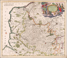
![(First state!) [ Upper Rhine River Valley -- Strasbourg to Basle ] Alsatia et Brisgoia II Rheni Et VII Nova Tabula](https://storage.googleapis.com/raremaps/img/small/94641.jpg)
![[Besançon] Vesontio Sequanorum Gallis Bensan son Germanis Byzantz](https://storage.googleapis.com/raremaps/img/small/76977.jpg)