|
||

|

|
|

|
Stock# 77654
Description
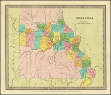
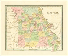
Scarce pre-Civil War map of Missouri, colored by counties and townships. Shows towns, roads, mountains, rivers, railroads, lakes, etc., which appeared in Charles Morse's General Atlas of the World.
Unlike most maps in Charles Morse's Atlas which are simply updated copies of maps from Morse & Breese's North American Atlas of 1845 , the map of Iowa is an entirely original production, replacing the Iowa and Wisconsin map which appeared in the 1845 work.