
This item has been sold, but you can enter your email address to be notified if another example becomes available.


|
||

|

|
|

|
Stock# 77646
Description
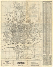
Vintage 1950s street map of the city of Phoenix, printed in attractive desert colors. The map shows the city from Sunnyslope and Paradise Valley down to Sky Harbor Airport and Salt River. The map is extremely detailed, with numerous streets, buildings, parks, neighborhoods, and other places of interest named.
The verso includes additional maps of South Phoenix, Tempe, Mesa, and a map of the Greater Phoenix area. Again, detail is extensive.
Surrounding the map are numerous advertisements, providing insight on the 1950s draw of Phoenix. This showcases land developments, car rental companies, and much more.
Condition Description
Folding map, printed both sides. Very minor loss in upper margin.
![[ Upper California ] Map of the Californias By T.J. Farnham](https://storage.googleapis.com/raremaps/img/small/99592.jpg)