|
||

|

|
|

|
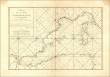
A striking German propaganda poster from the First World War, showing the sinking of Entente ships by German U-boats in the Mediterranean and Bay of Biscay. The map was published by the German Admiralstab der Marine (Admiralty Office) in late 1917 or early 1918.
The map has an aggressive visual style, which is heightened by the contrasting red and black gothic script of the title, and the yellow, black, and blue of the main image.
In 1917, having failed to find decisive victories on the terrestrial fronts of the First World War, Germany refocused on dominating the high seas. The strategy was based on the hope that Italy, France, and Britain could be forced to surrender if they were starved of vital imports.
To this end, Germany fielded over 100 submarines in early 1917, with many more in production to offset losses and expand the campaign's coverage. Together these U-boats were able to destroy 500,000 tons of shipping or more in February, March, April, May, and June. In April, the campaign had been so effective that it reduced Britain's wheat supply to six weeks' worth.
The campaign had one almost immediate and very serious drawback from Germany, as it probably contributed, at least in part, to the April 6, 1917, entrance of the United States into the war.
Additionally, tactics were developed to render the German submarine campaign less effective. This involved grouping merchant ships together in convoys that could be more easily defended by anti-submarine forces, as well as the development of more effective anti-submarine weapons.
This map was produced when the campaign was at or near its highpoint and when the German government was desperate for war victories to boost morale at home.
In all, this is a cornerstone example of persuasive mapmaking and data visualization from the first World War.
Translation of Notes
In the Balkans: [Symbol of a sinking ship]: bedeutet ein durch die Tätigkeit unserer U-Boote versenktes Schiff ohne Berücksichtigung seiner Grosse. [...means a ship sunk through the activity of our submarines, regardless of size.]
In Spain: Alle durch Minen und vor dem 1. Februar 1917 vernichteten Schiffe sind in dieser Karte nicht enthalten. [Ships destroyed by mines or before 1 February 1917 are not shown on this map.]
In northwest Africa: 12 Monate uneingeschränkten U-bootskrieges auf dem Mittlemeer-Kriegsschauplatz. [12 months of unrestricted submarine warfare in the Mediterranean war arena.]
In Libya, etc.: "Die wichtigste unmittelbare militärische Ursache der italienischen Niederlage wird unwidersprochen in dem Mangel an Munition und schweren Kanonen erblickt: denn die Unterseeboote haben die Erz- und Kohlenzufuhr unterbunden." (New York Times, 4.11.17.) ["The most important direct military cause of the Italian defeat is indisputably the lack of munitions and heavy artillery: the submarines have interdicted the supply of ore and coal." (New York Times, 4.11.17.)]
States and Rarity:
This is the latter of at least two states. The earlier edition, which can be seen here, referred to 11 months of unrestricted submarine warfare, rather than the 12 mentioned here.
As of July 2021, OCLC listed six institutional holdings all of them in Germany: Staatsbibliothek zu Berlin, Universitat Leipzig, Universitats- und Landesbibliothek Darmstadt, Universiteit Utrecht, Bayerische Staatsbibliothek, and the Deutsche Nationalbibliothek Leipzig. Not the Rumsey Collection nor the PJ Mode Collection. The Imperial War Museum also has an example.
![Carte De La Syrie [Shows Cyprus and the Holy Land!]](https://storage.googleapis.com/raremaps/img/small/61321.jpg)