This item has been sold, but you can enter your email address to be notified if another example becomes available.


|
||

|

|
|

|
Stock# 77614
Description
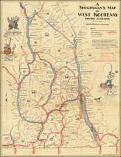
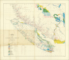
A Blue Print To Early British Columbia Railroads
Rare separately published map of British Columbia, illustration the Great Natural Divisions of the province.
The province is divided into:
- The Kootenays
- Southern Interior
- West Coast
- Central Interior
- Northern Interior
- Peace River
The map provides a fine overview of the operating railroads, rivers, lakes and other natural features.
Rarity
The map is very rare on the market. This is the first example we have seen.
![(Nothern Half) [Bancroft's Map of the Pacific States]](https://storage.googleapis.com/raremaps/img/small/54924.jpg)
![[Alaska, Northwest Coast and North Pacific Ocean] Der Noerdliche Theil des Grossenwelt Meeres . . . 1804](https://storage.googleapis.com/raremaps/img/small/80463.jpg)
![[British Columbia]. Routes of the Canadian Pacific Railway Company's Steamers British Columbia Coast Service](https://storage.googleapis.com/raremaps/img/small/83915.jpg)