|
||

|

|
|

|
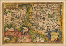
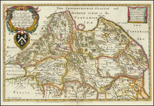
Speed's pocket map of Tartary, the region of Russia now known as Siberia. The map shows a massive stretch of land, reaching from the Caspian and Black Seas through to America and the Strait of Anian.
Polar detail is particularly interesting, with Nova Zembla having "the huys (house) of William Barents" shown. East of this is the Tartarian Frozen Sea and the Promontory Tabin. Korea (Coreains) is shown as an island. Numerous cities and regions are named, some fictional (e.g., Tagalistan).
This map originally appeared in Speed's Epitome. The maps in this volume were engraved by Peter Van Den Keere (Petrus Kaerius).
John Speed (1551 or '52 - 28 July 1629) was the best known English mapmaker of the Stuart period. Speed came to mapmaking late in life, producing his first maps in the 1590s and entering the trade in earnest when he was almost 60 years old.
John Speed's fame, which continues to this day, lies with two atlases, The Theatre of the Empire of Great Britaine (first published 1612), and the Prospect of the Most Famous Parts of the World (1627). While The Theatre ... started as solely a county atlas, it grew into an impressive world atlas with the inclusion of the Prospect in 1627. The plates for the atlas passed through many hands in the 17th century, and the book finally reached its apotheosis in 1676 when it was published by Thomas Bassett and Richard Chiswell, with a number of important maps added for the first time.