


|
||

|

|
|

|
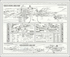
Attractive set of aerial photographs overlaid with a street map showing cities on the northwest coast of Oahu. Street names are provided, and the areal photographs show good resolution and are expertly stitched together.
Five separate images are shown, which outline the towns of Waimanalo, Kokahi, Kaneohe, and Kailua. A map shows the locations of these towns on the island, and an index and further drawings are provided.
The map names the northwestern side of the island the windward side, that is, the side exposed to the cool trade winds, which allow for ample rainfall. As such, this side of the island is generally wetter. The verso of this map describes the windward side's history and culture, from its earliest mentions through the colonial period.
![[Hawaii] Carte Des Isles Sandwich](https://storage.googleapis.com/raremaps/img/small/77881.jpg)
![(Photograph album) America | Hawaii. 1885. [Photographic album of Hawaii, Yellowstone, Utah, Colorado, and Niagara Falls]](https://storage.googleapis.com/raremaps/img/small/87949.jpg)