


|
||

|

|
|

|
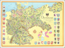
Post-World War II German Irredentism.
A stunning mid-century pictorial map of Germany, produced as internal and international debate raged regarding the extent and possibility of German reunification.
The map shows the German borders in the midst of Nazi rule. The German state that existed on December 31, 1937, represented the furthest territorial extent the country reached without breaking international law. Thus, following the end of the war, some nationalists advocated that these borders should be reinstated after unification.
The map is fantastically decorated, with pictorial elements that highlight traditional German culture. Towns and cities are shown throughout the map, and detail on the largest of these cities is particularly impressive. In addition, the coats of arms of the major cities are shown and a quote by Goethe, appropriated from his West-ostlicher Divan reads:
Those who know themselves and others will also recognize here: Orient and Occident can no longer be separated.
While Goethe was originally referring to European exchange with the Muslim and East Asian worlds, the reappropriation here is poignant.
The map likely dates to between 1953 (when this political issue arose). Evidently-later editions exist, including a smaller edition that shows a change in the inset of Germany in the lower right.
The changes to the German inset are curious. On the presented map, the region appears to be divided into the states of West Germany, and the historical regions of East Germany. Pomerania and Schlesien are marked "Unter Polnisch Verwaltung," while no such notes appear in East Prussia. On the smaller edition, the "Bundes Republik," and the "DDR" (with scare quotes included) are marked. Areas under Polish administration are marked, and Konigsburg is divided into a Polish and a Soviet sector. During the period when this map was likely produced, there would have been few changes in the geopolitical map (other than the finalization of the division of Konigsburg). As such, this change likely reflects the publisher's preferences than changes over time.
The lack of recognition of the East German state and Polish control, as with the general 1937 subject matter and the traditional German depictions raises questions as to who would have wanted this map. Published about a decade after the end of the Second World War, this work of persuasive cartography is reminiscent of the height of Nazi propaganda.
"The German Question"
The German Question concerns the extent to which the German-speaking populations of Europe should be united under a single leadership, and dates from the 19th century. Originally, the Question primarily regarded whether or not Austria should be a part of German unification, however, the rapid expansions and contractions of the German state in the first half of the 20th century superseded this issue.
The Question returned as a zeitgeist following the division between East and West Germany following the Second World War. Following the suppression of uprisings in East Germany in 1953, West Germans began to debate the possibility of eventual reunification. Since the Soviet Union had deliberately stripped much land that had formerly belonged to Germany from the GDR, including the core of the old Kingdom of Prussia, the borders under which the country would be reunited were uncertain.
Many Germans sought to argue that the borders should return to their configuration on December 31, 1937, a date which postdates the legal annexation of the Saar but predates Anschluss and the invasion of Czechoslovakia. These were also the borders that had been used by the Allies when first dividing up Germany. However, following the dissolution of the Soviet Union, part of Germany shown here would be divided between Russia and Poland, and the country would be much reduced in size.
![(Second World War - Anti-Nazi Propaganda) [Adolf Hitler as a Dog-like Prisoner.]](https://storage.googleapis.com/raremaps/img/small/91913.jpg)
