


|
||

|

|
|

|
Decorative chart of the Solent, Isle of Wight and adjacent mainland coastline, published by the Depot de la Marine. ]
The chart extends from the mouth of Poole Harbour to Sothampton and Selsey Bill, incorporating significant historical maritime coastal regions and areas well-known to leisure sailors today. Included are Christchurch, Lymington, Portsmouth and Hayling Island. The title appears in a large, decorative cartouche at lower left along with an explanatory key. The mileage scale runs up the right side of the map. A practical chart by one of the most well-known figures of the French hydrographical department.
The chart was issued in the standard French chart book of the period, the "Atlas Neptune" issued by the Depot De la Marine under the control of Jacques Nicolas Bellin. One of the best charts to cover the area.
Jacques-Nicolas Bellin (1703-1772) was among the most important mapmakers of the eighteenth century. In 1721, at only the age of 18, he was appointed Hydrographer to the French Navy. In August 1741, he became the first Ingénieur de la Marine of the Dépôt des cartes et plans de la Marine (the French Hydrographic Office) and was named Official Hydrographer of the French King.
During his term as Official Hydrographer, the Dépôt was the one of the most active centers for the production of sea charts and maps in Europe. Their output included a folio-format sea atlas of France, the Neptune Francois. He also produced a number of sea atlases of the world, including the Atlas Maritime and the Hydrographie Francaise. These gained fame and distinction all over Europe and were republished throughout the eighteenth and even in the nineteenth century.
Bellin also produced smaller format maps such as the 1764 Petit Atlas Maritime, containing 580 finely-detailed charts. He also contributed a number of maps for the 15-volume Histoire Generale des Voyages of Antoine François Prévost.
Bellin set a very high standard of workmanship and accuracy, cementing France's leading role in European cartography and geography during this period. Many of his maps were copied by other mapmakers across the continent.
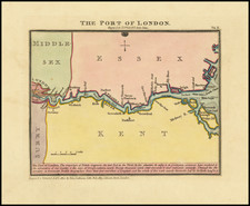
![[ Thames Estuary, etc ] Carte de L'Entree de la Tamise... Sandwich et Clay.](https://storage.googleapis.com/raremaps/img/small/73808.jpg)