|
||

|

|
|

|
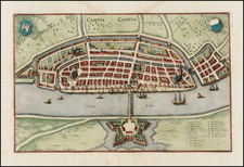
Attractive original antique plan of the fort in Antwerp, built during the Dutch Revolt to protect the city. Following the publication of this map, it would see significant action during the Napoleonic Wars, where it would be defended by reluctant to surrender Bonapartists. It would be destroyed in the late 18th century, and is now hope to the present-day neighborhood of Zuid.
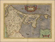
Luffman's Select Plans is an uncommon traveler's guide that served to educate the intrepid traveler regarding any part of the world, from the major cities of Europe to the wild coasts of the Spice Islands. Each of Luffman's maps contained detailed coastal descriptions showing the major landmarks and cities, as well as basic but necessary navigational information. This plate appeared in the first of Luffman's two volumes.
![[ Lower Rhine River & Wesser River Region ] Die dritte Tafel des Rheinstroms / Innhaltend das Nider Teutschlandt](https://storage.googleapis.com/raremaps/img/small/81288.jpg)