


|
||

|

|
|

|
Stock# 77438
Description
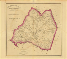
Scarce Revolutionary War Era Map Showing the Seat of War in the Southern Colonies
Detailed map of the Carolinas and Virginia, illustrating the progress of the American Revolutionary War, prepared by Thomas Kitchen for the June 1781 edition of the London Magazine.
The map extends from the Chesapeake, Gloucester and Henrico Counties in the Northeast, to the Fluvanna River and the southern Alleghany Mountains and Blue Mountains in the Northwest and from the Camden and Ninety Six Districts in South Carolina in the Southwest to the Coast and the mouth of the Great Pedee River in South Carolina along the East Coast.
Condition Description
Toned.

![[ Cape Hatteras to New York City ] The Coast of the United States of North America; from New York to St. Augustine: Drawn and regulated according to the latest Surveys and Astronomical Observations By Edmund Blunt. Additions to 1839 & 1840](https://storage.googleapis.com/raremaps/img/small/84684.jpg)
![(18th-Century Southern Borderlands) [Collection of manuscript letters to Secretary of War James McHenry from confidential U.S. agent John McKee, relating to southern borderlands, Native Americans and Panton, Leslie & Co.; a letter from John McKee written from Mobile, Alabama, to William Blount of Blount's Conspiracy fame; a letter from William Panton concerning John McKee; and letters from Felix D. St. Hilaire, concerning General Victor Collot]](https://storage.googleapis.com/raremaps/img/small/90005.jpg)