


|
||

|

|
|

|
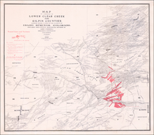
Through the Rocky Mountains -- By Tunnel!
Fascinating post card map and view, promoting the lines of the Atlantic-Pacific Railway Tunnel through the Rocky Mountains.
On one side is a fascinating cross sectional profile view of the Rocky Mountains, showing the proposed Denver Apex and Western Railway tunnel through the mountains, cutting the distance from the Missouri River to the Pacific Coast by 233 miles. According to the note under the view, a 36-page pamphlet and map of Colorado were available upon request, though they are not present here.
Atlantic-Pacific Railway Tunnel
In 1884 the Atlantic-Pacific Railway Tunnel Company was created "to drive a tunnel for both mining and railway purposes through the Continental Divide." Its properties consist of extensive and valuable real estate, mill sites, and mining claims, including the celebrated brought to her. This could only be done by tunnelling, and so Mr. Pomeroy conceived the idea of the Atlantic-Pacific Tunnel.
Pomeroy started prospecting and surveying and discovered that the distance through the great divide, from the base of Mount Kelso, under its apex, and on under the apex of Cray's Peak, was just under five miles. A tunnel through these mountains would enable Denver to have a gateway through the Rockies and shorten the railway distance between Denver and Salt Lake City by more than two hundred and fifty miles.
In all, Pomeroy raised nearly $2.4 Million, but the effort to complete the tunnel failed in part because of the Financial Panic of 1893, and it would be another 30 years before the Moffat tunnel would successfully complete the route from one side to another through the Continental Divide.
![Johnson's Nebraska, Dakota, Montana and Kansas [Rare Pre-Wyoming Territory configuration]](https://storage.googleapis.com/raremaps/img/small/94909.jpg)
![Indian Territory [with Colorado on verso]](https://storage.googleapis.com/raremaps/img/small/74706.jpg)
![(Black Canyon of the Gunnison National Park) Western Colorado And Part of Utah [Sheet VIII]](https://storage.googleapis.com/raremaps/img/small/88720.jpg)
![(Colorado Springs Photograph) [Original cabinet card albumen photograph of Tejon Street, Colorado Springs, looking south toward Cheyenne Mountain]](https://storage.googleapis.com/raremaps/img/small/87515.jpg)
![[Austins Colony] Mexico & Guatemala](https://storage.googleapis.com/raremaps/img/small/94054.jpg)