This item has been sold, but you can enter your email address to be notified if another example becomes available.


|
||

|

|
|

|
Stock# 77393
Description
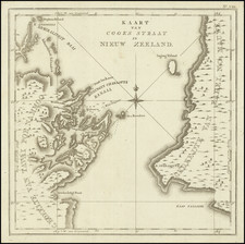
Wonderful bird's-eye view map of the Lake Taupo and Lake Rotorua "thermal region" on the North Island of New Zealand.
The map is the centerfold image in a pamphlet issued by the New Zealand Tourism Department in 1923.
Geyers and other volcanic activity are illustrated pictorially throughout the map.
A wonderful treatment of this unusual region.
Condition Description
Folding pamphlet map. Two staples at the central vertical fold.