|
||

|

|
|

|
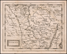
Extremely rare Le Clerc edition of Johann Baptiste Vrients map of the region around Lake Geneva, which first appeared in the 1603 edition of Ortelius' Theatrum Orbis Terrarum.
For this map, Le Clerc has engraved an entirely new plate, although the maps are very similar. The map was also later copied by both Hondius (c 1630) and Tavernier (c 1643).
The map is very rare. We have located two similar maps, one in the British Library, which references only Jean Le Clerc, and one in the Bibliotheque National de France, which lists Picart is catalogued with the following entry: "H. Picart fecit, Johannes Le Clerc excudit". The present example lists Picart as "Sculp."
Jean Le Clerc was an engraver, bookseller and publisher in Paris and Tours.
Le Clerc was baptized on August 16, 1560 in Paris, with the engraver François Desprez (1530–1587) and the painter Jérôme Bollery (1532–1592) as his godfathers. He came from a family of printers and publishers - Jean's younger brother David Le Clerc (1561–1613) and Jean's own son Jean Le Clerc V were both book printers and publishers.
He had proved himself by 1587, at which date he was living and working on Rue Chartière in Paris. For religous reasons, as a Huguenot he fled Paris in 1588 and spent a year elsewhere in France. From 1590 to 1594 he took refuge in Tours, where he worked with the publisher and cartographer Maurice Bouguereau (15??–1596), who created Le Theatre Francoys, the first atlas of France. Le Clerc later worked at several different addresses in Paris - on Rue Saint-Jean-de-Latran until 1610 and then on Rue Saint-Jacques until 1621/24.
Jean Le Clerc's publications included portraits, maps, contemporary news events and other engravings by Jacques Granthomme (1560–1613), Pierre Firens (1580–1636) and Léonard Gaultier (1561–1635). He collaborated with the Dutch printmaker Thomas de Leu (1560–1612) to produce a collection of 179 biblical scenes, allegories, calendar pages and other works, probably published in 1606. They both produced engravings for it themselves as well as using works by Justus Sadeler (1580–1620), Isaac Briot (1585–1670) and Nicolas Briot (1579–1646).
On December 20, 1619 Le Clerc was granted a six-year royal concession to "engrave maps of the provinces of France and portraits of patriarchs and princes of the Hebrew people, with a chronological history". In 1620 he published his Le Théâtre géographique du Royaume de France, including newer plates as well as reworked plates from Bouguereau's work. The new plates were produced by artists such as Jean Fayen (1530–1616), Jodocus Hondius (1563–1612), Salomon Rogiers (1592–1640) and Hugues Picart (1587–1664). It went through several editions and Jean Le Clerc V continued to reissue it after his father's death.
![[Artois] Comitatuum Artesiae Boloniae et Guines Novissima Descriptio](https://storage.googleapis.com/raremaps/img/small/78978.jpg)