


|
||

|

|
|

|
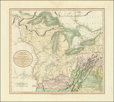
Henry Schenk Tanner's engraved map of Iowa - one of the earliest obtainable territorial maps of Iowa, first published one year prior to statehood.
Iowa was organized as a Territory in 1838. The initial 20 counties extended to the Indian Treaty Line. The counties west of the line did not appear until after 1843 (Blackhawk, Tama, Powesheik, Mahaska, Kishkeekosh, Appanoose, Davis, Walpello Keokuck, Iowa, Benton and Buchannan).
The map is dominated by the Indian Lands of the Iowas, the Sauks and Foxes and the Sioux, along with a wide swath of Neutral Land separating the latter two tribes. This map shows the Indian Lands as technically a part of Clayton County, as per the 1840 Census. This map shows the extent of the early state surveys, counties, towns, courthouses in each county, roads, rivers, lakes and Indian detail.
Among Atlas maps, Tanner's map preceded only by the 1842-43 map of Iowa Territory by Carey & Hart, showing 20 counties. The earliest appearance of Iowa on a commercial atlas map is on the Morse & Breese/Nicollet map of Iowa and Wisconsin, which predates the formation of Minnesota Territory. Galland's map of Iowa issued in 1840 also predates this map, but did not appear in a commercial atlas. Several early government survey maps were also issued prior to 1845.
An essential map for Iowa collectors.
![[Eastern Sheet -- Ohio] Post Road Map of the States of Ohio and Indiana with Adjacent Parts of Pennsylvania Michigan Illinois Kentucky and West Virginia Showing Post Offices With The Intermediate Distances and Mail Routes In Operation On the !st of February 1885 . . .](https://storage.googleapis.com/raremaps/img/small/44153.jpg)

![Comparative Size of Lakes and Islands [Great Lakes, Cuba, Formosa, Ireland, Sicily, Cyprus, Vancouver, Sandwich Islands, Puerto Rico, Corsica, Sardinia, Balearics, Malta, etc]](https://storage.googleapis.com/raremaps/img/small/92574.jpg)