|
||

|

|
|

|
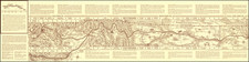
The Earliest Obtainable Bird's-Eye View of Minneapolis.
Important antique bird's-eye view of Minneapolis, Minnesota, published by A.T. Andreas in the special edition of his 1874 Illustrated Historical Atlas of the State of Minnesota.
The view faces west over the Mississippi from what was then known as the town of St. Anthony, towards the present-day downtown of Minneapolis.
This is the earliest obtainable detailed bird's-eye view of Minneapolis. It is the third bird's-eye view of Minneapolis overall, after the Hageboeck (1873) and Ruger (1867), neither of which have traded in modern records.
The view is one of the best visual documents of the composition of the city's early economy, which revolved around the hydropower of St. Anthony Falls.
The original span of the Hennepin Avenue Bridge can be seen; this is believed to have been the first permanent span across the Mississippi at any point.
The view includes a very detailed key below the image. From left to right (south to north) it reads:
Tremont House, East Side.
Lower Bridge.
E.S. Fence Factory.
Lower Feed Mill. East Side.
Lougy Grist Mill, E.S.
City Gas Works.
Hubbard's Harvester Works.
Jackson School.
M.E. Church.
Todd & Haven -
Butler & Lane - Saw Mill, E.S.
Franklin Ave. Church.
Norwegian Bap. Church.
Washburn Flour Mill.
Baptist Church.
Linseed Oil Works.
Todd Shingle Mills.
McMullin's Shingle Mills.
Averall & Russell's Paper Mill.
Shing Machine Factory.
Eave Through Factory.
Congregational Church.
M. & St. P. Elevator.
W.D. Washburn Flour Mill.
Rollin's Flour Mills.
Pillsbury & Fisk Flouring Mills.
Cotton Mills.
Sash and Door Factory.
Bag Factory.
St. Anthony Falls.
Farnum and Lovejoy's Saw Mill.
Court House and Jail.
Park Ave. Church.
Presbyterian Church.
Cataract House.
Gibson and Tylor Blanket Mills.
Minneapolis Iron Works.
R.R. Machine Shop.
Saw Mill.
Water Works.
Bushnell & Howes' Machine Shop.
First Universalist Church.
Universalist Church.
Centenary M.E. Church.
Baptist Church.
Washington School.
M. & St. P. R. R. Depot.
Minneapolis & Duluth R. R. Depot.
McCallester College, E. Side.
First National Hotel.
St. Mark's Episcopal.
Congregation Church.
Plymouth Church.
Warner's Block.
Westminster Church.
Brackett's Block.
Rarity
The view appears only in the two "deluxe" editions of the Andreas atlas. This view was accompanied in that atlas by views of St. Paul and Winona.
Alfred T. Andreas (1839-1900) was a tour de force when it came to commercial cartography and promotion. He built a sales machine that had agents crisscrossing the states he intended to map, selling subscriptions in return for portraits being placed in the back of his atlases. Andreas was especially active in the Upper Midwest; he was responsible for state atlases of Minnesota (1874), Illinois (1876), Wisconsin (1878), and Iowa (1875).
Ristow says of Andreas' plans for future state atlases:
ANDREAS anticipated that the Minnesota volume would be the first in a series of illustrated state historical atlases. As soon as his surveyors and canvassers had completed their work in Minnesota, they were accordingly shifted to Iowa to begin work on an atlas there. Procedures for preparing the Iowa atlas and for soliciting subscriptions and contracts for illustrations and biographical sketches were the same as for the Minnesota volume.
![(Chicago World's Fair & St. Paul, Minn.) [Contemporary album of 71 Photographs of St. Paul and Chicago World's Fair, Columbian Exposition]](https://storage.googleapis.com/raremaps/img/small/87334.jpg)

![Bancroft Freeborn Co. MT [Minnesota Territory]](https://storage.googleapis.com/raremaps/img/small/82401.jpg)